- Old Dongola
-
Dunqulah al-ʿAjūz
Old Dongola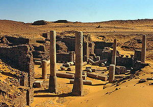 Location in Sudan
 Dunqulah al-ʿAjūz
Coordinates: 18°13′N 30°45′E / 18.217°N 30.75°E Country  Sudan
SudanState Old Dongola (Old Nubian: Tungul; Arabic: Dunqulah al-ʿAjūz) is a deserted town in Sudan located on the east bank of the Nile opposite the Wadi Al-Malik. An important city in medieval Nubia, and the departure point for caravans west to Darfur and Kordofan, from the fourth to the fourteenth century Old Dongola was the capital of the Makurian state. The urban center of the population moved downstream 50 miles (80 km) to the opposite side of the Nile during the nineteenth century, becoming the modern Dongola.
A Polish archaeological team has been excavating the town since 1964.
History
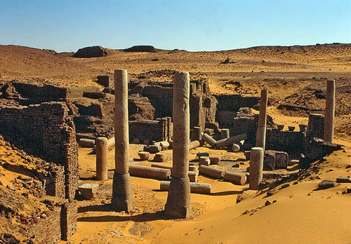
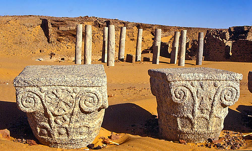
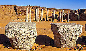 The Church of the Granite Columns
Old Dongola was founded in the fifth century as a fortress, but town soon evolved around it. Later with the arrival of Christianity it became the capital of Makuria, and several churches were built. These include, to use the names contemporary archeologists have given them, Building X and the Church with the Stone Pavement. These two structures were erected about 100 meters apart from the walled town centre, indicating that at this time the town already extended over the original walls of the fortress. Building X was soon replaced by the Old Church.
In the middle of the seventh century, the two main churches were destroyed, but rebuilt soon after. Building material was taken from the Old Church and used to repair the city walls. Archeologists believe this destruction is evidence that the First (642) and Second Battles of Dongola (652).
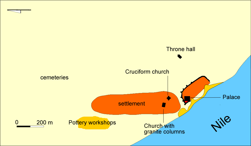
 Plan of Old Dongala in the Medieval Period
At the end of the seventh Century, the Church of the Granite Columns was erected over the Old Church. Adorned with 16 granite columns, each with richly decorated granite capitals, the Church of the Granite Columns perhaps was the cathedral of Old Dongola.
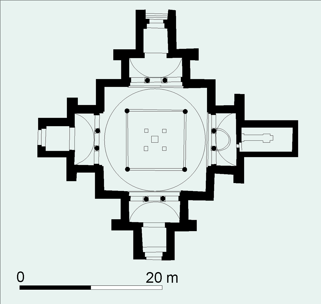
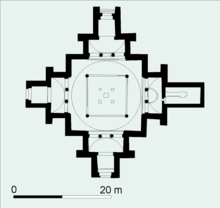 The Cruciform Church (plan)
The hey day of old Dongola was in the tenth century, Old Dongola. The Church of the Stone Pavements was replaced with the Cruciform Church at this time. Other buildings in use in Old Dongola at this time include many other churches, at least two palaces, and a sizable monastery on its north side. Several houses were well equipped and had bath rooms and wall paintings.
The Book of Knowledge, a travelogue compiled by a Spanish monk soon after 1348, mentions that Genoese merchants had settled in Old Dongola; they may have penetrated thither as a consequence of the commercial treaty of 1290 between Genoa and Egypt.[1] However, during the thirteenth and fourteenth centuries the town was in decline. It was attacked by Arabs several times, and the throne room of the palace was converted to a mosque. A surviving inscription Sayf al-Din Abdullah Barshambu erected in Old Dongola and bears the date of 1317, is commonly understood to be the record of a military expedition sent by the Sultan of Egypt to place his nominee Abdullah, perhaps a Muslim Nubian, on the throne.[2]
Under the Funj, Old Dongola became the capital of the Northern provinces. The traveller C.J. Poncet visited the city in 1699, and in his memoirs he described it as located on the slope of a sandy hill. His description of Old Dongola continues:
- The houses are ill built, and the streets half deserted and fill'd with heaps of sand, occasion'd by floods from the mountains. The castle is in the very center of the town. It is large and spacious, but the fortifications are inconsiderable. It keeps in awe the Arabians, who are masters of the open country.[3]
Notes
- ^ O.G.S. Crawford, "Some Medieval Theories about the Nile", Geographical Journal, 114 (1949), pp. 7f
- ^ P. L. and M. Shinnie, "New Light on Medieval Nubia", Journal of African History, 6 (1965), p. 265
- ^ Charles Jacques Poncet in The Red Sea and Adjacent Countries, William Foster, editor (London: Hakluyt Society, 1949), pp. 99f.
Categories:- Nubia
- Archaeological sites in Sudan
- Populated places in Sudan
- Northern (state)

Wikimedia Foundation. 2010.