- Mount Harwood
-
Mount Harwood
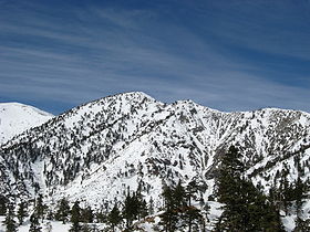
Mount Harwood (center) and Devil's Backbone (right) from the southeast, February 2008.Elevation 9,552 ft (2,911 m) NGVD 29[1] Prominence 152 ft (46 m) [1] Parent peak Mount San Antonio Listing Sierra Club Hundred Peaks List [2] Location Location San Bernardino County, California, USA Range San Gabriel Mountains Coordinates 34°17′11″N 117°37′59″W / 34.2863929°N 117.6331103°WCoordinates: 34°17′11″N 117°37′59″W / 34.2863929°N 117.6331103°W[3] Topo map USGS Mount San Antonio Climbing Easiest route Hike, class 1 [2] Mount Harwood is the first summit east of Mount San Antonio. The United States Geological Survey recognized the name to honor California educator and conservationist Aurelia Squire Harwood in 1965.[3] Prior to this, the peak now known as Thunder Mountain was also referred to as Mount Harwood.[4]
Gallery
References
- ^ a b "Mount Harwood, California". Peakbagger.com. http://www.peakbagger.com/peak.aspx?pid=1340. Retrieved 2009-01-25.
- ^ a b "Mount Harwood". Hundred Peaks Section List. Angeles Chapter, Sierra Club. http://angeles.sierraclub.org/hps/guides/16J.htm.
- ^ a b "Mount Harwood". Geographic Names Information System, U.S. Geological Survey. http://geonames.usgs.gov/pls/gnispublic/f?p=gnispq:3:::NO::P3_FID:271508. Retrieved 2009-01-25.
- ^ "Thunder Mountain". Geographic Names Information System, U.S. Geological Survey. http://geonames.usgs.gov/pls/gnispublic/f?p=gnispq:3:::NO::P3_FID:255754. Retrieved 2009-01-25.
Categories:- San Gabriel Mountains
- Mountains of San Bernardino County, California
- San Bernardino County, California geography stubs
Wikimedia Foundation. 2010.


