- Lā'ie, Hawai'i
Infobox Settlement
official_name = Laie, Hawaii
other_name =
native_name =
nickname =
settlement_type = CDP
motto =.jpg)
imagesize =
image_caption = TheLaie Hawaii Temple , the fifth oldest Mormon temple worldwide
flag_size =
image_
seal_size =
image_shield =
shield_size =
image_blank_emblem =
blank_emblem_type =
blank_emblem_size =
flag_size =
image_
seal_size =
image_shield =
shield_size =
image_blank_emblem =
blank_emblem_type =
blank_emblem_size =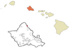
mapsize = 250px
map_caption = Location in Honolulu County and the state ofHawaii
mapsize1 =
map_caption1 =
image_dot_
dot_mapsize =
dot_map_caption =
dot_x =
dot_y =
pushpin_
pushpin_label_position =
pushpin_map_caption =
pushpin_mapsize =
subdivision_type = Country
subdivision_name =United States
subdivision_type1 = State
subdivision_name1 =Hawaii
subdivision_type2 =
subdivision_name2 =
subdivision_type3 =
subdivision_name3 =
subdivision_type4 =
subdivision_name4 =
government_footnotes =
government_type =
leader_title =
leader_name =
leader_title1 =
leader_name1 =
leader_title2 =
leader_name2 =
leader_title3 =
leader_name3 =
leader_title4 =
leader_name4 =
established_title =
established_date =
established_title2 =
established_date2 =
established_title3 =
established_date3 =
area_magnitude =
unit_pref = Imperial
area_footnotes =
area_total_km2 = 5.5
area_land_km2 = 3.3
area_water_km2 = 2.2
area_total_sq_mi = 2.1
area_land_sq_mi = 1.3
area_water_sq_mi = 0.9
area_water_percent =
area_urban_km2 =
area_urban_sq_mi =
area_metro_km2 =
area_metro_sq_mi =
area_blank1_title =
area_blank1_km2 =
area_blank1_sq_mi =
population_as_of = 2000
population_footnotes =
population_note =
population_total = 4585
population_density_km2 = 1390.6
population_density_sq_mi = 3601.7
population_metro =
population_density_metro_km2 =
population_density_metro_sq_mi =
population_urban =
population_density_urban_km2 =
population_density_urban_sq_mi =
population_blank1_title =
population_blank1 =
population_density_blank1_km2 =
population_density_blank1_sq_mi =
timezone = Hawaii-Aleutian
utc_offset = -10
timezone_DST =
utc_offset_DST =
latd = 21
latm = 38
lats = 55
latNS = N
longd = 157
longm = 55
longs = 32
longEW = W
elevation_footnotes =
elevation_m = 0
elevation_ft = 0
postal_code_type =ZIP code
postal_code = 96762
area_code = 808
blank_name = FIPS code
blank_info = 15-43250
blank1_name = GNIS feature ID
blank1_info = 0361691
website =
footnotes =Lāokinaie is a community and a
census-designated place (CDP) located in the Kookinaolauloa District on the Island of Ookinaahu, City & County of Honolulu. In Hawaiian, "lāokinaie" means "okinaie" leaf" ("okinaie" is a climbingpandanus : "Freycinetia arborea "). The population was 4,585 at the 2000 census.History
Historically, Laie was a "
pu'uhonua ", a sanctuary for fugitives. While a fugitive was in the pu'uhonua, it was unlawful for that fugitive's pursuers to harm him or her. During wartime, spears with white flags attached were set up at each end of the city of refuge. If warriors attempted to pursue fugitives into the "pu'uhonua", they would be killed by sanctuary priests. Fugitives seeking sanctuary in a city of refuge were not forced to permanently live within the confines of its walls. Instead, they were given two choices: In some cases, after a certain length of time (ranging from a couple of weeks to several years), fugitives could enter the service of the priests and assist in the daily affairs of the "pu'uhonua". A second option was that after a certain length of time the fugitives would be free to leave and re-enter the world unmolested. Traditional cities of refuge were abolished in 1819. [Mulholland, John F., "Hawaii's Religions", (Rutland, Vermont: Charles E. Tuttle Company, 1970), p. 121]The "mo'olelo" (history) of Laie begins long before first contact. The name Laie is said to derive from two Hawaiian words: "lau" meaning "leaf", and "ie" referring to the Ieokinaie vine of the red-spiked climbing pandanus tree ("
Freycinetia arborea ") which wreaths forest trees of the uplands or mauka regions of the mountains of theKoʻolau Range behind the community of Laie. InHawaiian mythology , this red-spiked climbing pandanus is sacred to Kane, god of the earth, god of life, and god of the forests, as well as toLaka , the patron goddess of thehula .The name La'ie becomes more environmentally significant through the Hawaiian
oral history ("kaokinaao ") entitled "Laieikawai". In this history, the term "ikawai", which means "in the water," also belongs to the food-producing tree called "kalalaikawa". The kalalaikawa tree was planted in a place called Paliula's garden, which is closely associated with the spiritual home, after her birth and relocation of Laieikawai. According to Hawaiian oral traditions, the planting of the kalalaikawa tree in the garden of Paliula is symbolic of the reproductive energy of male and female, which union in turns fills the land with offspring.4 From its close association with nature through its name, and through its oral traditions and history, the community of La'ie takes upon itself a precise identification and a responsibility in perpetuating life and in preserving all life forms. Sometimes the land itself provided sanctuary for the Hawaiian people. La'ie was such a place. The earliest information about La'ie states that it was a small, sparsely populated village with a major distinction: "it was a city of refuge." Within this city of refuge were located at least twoheiau traditional Hawaiian temples, of which very little remains today. "Moohekili" heiau was destroyed, but its remains can be found in taro patches "makai" (seaward) of theLaie Hawaii Temple . Towards the mountain ("mauka"), the remains of "Nioi" heiau can be found on a small ridge. All that is left of "Nioi" is a coral platform. [Sterling & Summers 1978, p. 158]Between 1846 and 1848, the traditional Hawaiian feudal ownership of land by the king, the ali'i nui, and his leading chiefs or konohiki was changed through the
Great mahele , or major land division. The Ali’i nui at the time was Kauikeouli King Kamehameha III and his konohiki (leading chief) for Laie was Peni Keali’iwaiwaiole (which means The Chief without Riches); the wife to this konohiki descended directly from the Ali’inui of O’ahu namedKakuiewa , making his wife of higher rank than he. The result of the mahele was not in compliance with the original intent of Kamehameha III. The result was that the chiefs received about one-and-a-half million acres, the king kept about one million acres, which were called crown lands, and about one million acres were set aside as government lands.The interesting thing about the mahele was that the land itself was cut up into parcels, much like the traditional Hawaiian land divisions, centering around the "
ahupua'a ", which followed a fairly uniform pattern. Each parcel was shaped roughly like a piece of pie with the tip in the mountains, the middle section in the foothills and coastal plain, and the broad base along the ocean front and the sea. The size and shape of the ahupua'a varied. However, the purpose of these remained the same. The village of La'ie is located in the ahupua'a of La'ie. As such, La'ie followed the general pattern of life in the ahupua'a, but only the valleys in the foothills had ample water. There were ten streams that flowed through the ahupua'aof La'ie before 1865 (see 1865 map). Their names were: Kahooleinapea, Kaluakauila, Kahawainui, Kaihihi, Kawaipapa, Kawauwai, Wailele, Koloa, Akakii, and Kokololio. There were more streams flowing through the ahupua'a of La'ie than through any of the other surrounding ahupua'a, surrounding ahupua'ainclude Kaipapau and Hauula to the southeast and Malaekahana, Keana, and Kahuku to the northwest.A new phase of development for Laie began when the plantation of that name was purchased by George Nebeker, the President of the Hawaiian Mission of
The Church of Jesus Christ of Latter-day Saints . The Latter-day Saints in Hawaii were then encouraged to move to this location. [Jenson, Andrew. "Encyclopedic History of the Church of Jesus Christ of Latter-day Saints". (Salt Lake City: Deseret News Press, 1941) p. 324] This purchase occurred in 1865. [Mulholland, "Hawaii's Religions", p. 122] The sugar plantation was rarely profitable, and through 1879 the church had subsidized its operations with about $40,000. [Mulholland, "Hawaii's Religions", p. 122]Soon after the settlement a sugar factory was built. Much of the land was used to grow sugar, but other food crops were also raised. Both schools and church buildings were constructed in the town in the ensuing years.
Samuel E. Woolley, who served as mission president for 24 years, pushed the expansion of the operations at Laie. In 1898 he negotiated a $50,000 loan that allowed for the building of a new pump. [Mulholland, "Hawaii's Religions", p. 123]
The Hawaiian mission was headquartered in Laie until 1919 when the headquarters were moved to Honolulu, but by then the temple had been built in Laie, so it remained the spiritual center of the Latter-day Saint community in Hawaii. [Jenson. "Encyclopedic History". p. 324]
Community
Lāokinaie is one of the largest communities of
The Church of Jesus Christ of Latter-day Saints and the site of the Lāokinaie Hawaiokinai Temple, the fifth oldest Mormon temple in the world. [ [http://www.lds.org/temples/chronological/0,11206,1900-1,00.html Chronological list of LDS temples] ] Brigham Young University Hawaiokinai is located in Lāokinaie. The university'sPolynesian Cultural Center , the state's largestliving museum , draws millions of visitors annually [http://www.polynesia.com/] .Though small, Lāokinaie has had a significant impact on Hawaiian culture, despite many of its residents' tracing their lineages from various Pacific Island countries such as
Tonga ,Samoa ,Fiji , andNew Zealand . Fundraisers and feasts on the beach in the late 1940s inspired "The Hukilau Song ," [ [http://www.polynesia.com/alii-luau/alii-luau-and-laie-hukilau.html History of the Hukilau Song] ] written, composed and originally recorded byJack Owens, The Cruising Crooner , and made famous byAlfred Apaka .The U.S.
postal code for Lāokinaie is 96762.Geography
Lāokinaie is located at coor dms|21|38|55|N|157|55|32|W|city (21.648500, -157.925569)GR|1. This community is located north from Hauokinaula and south from Kahuku along Kamehameha Highway (State Rte. 83).
According to the
United States Census Bureau , the CDP has a total area of 2.1square mile s (5.5km² ). 1.3 square miles (3.3 km²) of it is land and 0.9 square miles (2.3 km²) of it (40.65%) is water.The coastline is marked by a prominent lithified
dune jutting out into the ocean as Lāokinaie Point (also known as Laniloa Point, the elevated land formation with Lāokinaie Pt. at its tip). Two other lithified dunes (Kukuihookinaolua and Mokuālai) lie just offshore of the point as scenicislet s. Lāokinaie Beach Park, popularly known as Pounders Beach for the offshore surf site, is just south of the town. Lāokinaie Beach, also known asHukilau Beach , is located at the north end of town, at the mouth of Kahawainui Stream.Demographics
As of the
census of 2000,GR|2 there were 4,585 people, 903 households, and 735 families residing in the CDP. Thepopulation density was 3,601.7 people per square mile (1,393.9/km²). There were 1,010 housing units at an average density of 793.4/sq mi (307.1/km²). The racial makeup of the CDP was 27.59% White, 0.35% Black or African American, 0.15% Native American, 9.23% Asian, 36.88% Pacific Islander, 0.65% from other races, and 25.15% from two or more races. Hispanic or Latino of any race were 3.12% of the population.There were 903 households out of which 46.4% had children under the age of 18 living with them, 66.2% were married couples living together, 10.9% had a female householder with no husband present, and 18.6% were non-families. 9.1% of all households were made up of individuals and 2.1% had someone living alone who was 65 years of age or older. The average household size was 4.47 and the average family size was 4.75.
In the CDP the population was spread out with 31.8% under the age of 18, 21.8% from 18 to 24, 26.8% from 25 to 44, 14.5% from 45 to 64, and 5.1% who were 65 years of age or older. The median age was 24 years. For every 100 females there were 90.5 males. For every 100 females age 18 and over, there were 85.9 males.
The median income for a household in the CDP was $50,875, and the median income for a family was $59,432. Males had a median income of $40,242 versus $26,750 for females. The
per capita income for the CDP was $13,785. About 10.7% of families and 17.5% of the population were below thepoverty line , including 13.8% of those under the age of 18 and 11.6% of those ages 65 and older.References
Further reading
*cite journal
last = Aikau
first = Hokulani K.
title = Resisting Exile in the Homeland: He Mo'olemo No Lā'ie
journal = American Indian Quarterly
volume = 32
issue = 1
pages = 70-95
publisher = University of Nebraska Press
location = Lincoln, NE
date = Winter 2008
issn = 0095-182X
accessdate = 2008-07-18
*cite book
last = Dorrance
first = William H.
title = Ookinaahu's Hidden History: Tours Into the Past
publisher = Mutual Publishing
date = 1998
location = Honolulu, HI
pages =
isbn = 1-56647-211-3
*cite book
last = Sterling
first = Elspeth P.
coauthors = Catherine C. Summers
title = Sites of Oahu
publisher = Bishop Museum Press
date = 1978
location = Honolulu
pages = 155-160
isbn = 0910240736External links
Wikimedia Foundation. 2010.