- Morović
-
Morović (Моровић) is a village in northwestern Serbia in the Šid municipality, Srem District, autonomous province of Vojvodina. The village has a population of 2,164 people (2002 census), mainly of Serbian origin.
Contents
History
In the Middle Ages, Morović was a notable town. It was built by Serbian despot Stefan Štiljanović in 1498.[1] Štiljanović used Morović as his residence until he moved to Baranya, escaping the Ottomans.
Historical population
- 1961: 2,110
- 1971: 2,292
- 1981: 2,196
- 1991: 2,105
- 2002: 2,164
Features
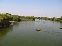
Morović lies on the banks of the Bosut and Studva rivers and is surrounded by opulent oak forests.
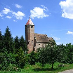
The old Catholic church from the 13th century, built in both romanesque and gothic styles is a very noteworthy monument. Jamena a nearby village can only be accessed by traveling through Morovic.
Sport and Hunting
Morović is most famous for its hunting area often referred to as Tito's hunting ground, it was one of his favorite hunting grounds in the time of Yugoslavia. In recent years it has attracted interest from international hunters with excellent facilities and accommodations dedicated to the sole purpose of hunting. The surrounding area contains an abundance of red deer, fellow deer, wild boar and pheasants. It spreads on 2500 hectares covered with magnificent centenary oaks. In the middle of the reserve there is Tito's hunting lodge with eight beds and another common hunting lodge with about twenty beds. The infrastructures are very good and all the reserve is very well looked after. The area also hosts a well known fishing tournament every year, the area is popular with anglers due to the surrounding rivers around Morović.
The local football club is FK Jedinstvo Morović, it currently competes in the VOJVOĐANSKA LIGA - JUG(South) which is the equivalent fourth division.
See also
- List of places in Serbia
- List of cities, towns and villages in Vojvodina
References
- Slobodan Ćurčić, Broj stanovnika Vojvodine, Novi Sad, 1996.
External links
Cities, towns and villages in the Syrmia District Sremska Mitrovica Bešenovački Prnjavor · Bešenovo · Bosut · Veliki Radinci · Grgurevci · Divoš · Zasavica I · Zasavica II · Jarak · Kuzmin · Laćarak · Ležimir · Manđelos · Martinci · Mačvanska Mitrovica · Noćaj · Ravnje · Radenković · Salaš Noćajski · Sremska Rača · Stara Bingula · Čalma · Šašinci · Šišatovac · ŠuljamInđija Irig Velika Remeta · Vrdnik · Grgeteg · Dobrodol · Jazak · Krušedol Prnjavor · Krušedol Selo · Mala Remeta · Neradin · Rivica · ŠatrinciPećinci Ruma Buđanovci · Vitojevci · Voganj · Grabovci · Dobrinci · Donji Petrovci · Žarkovac · Klenak · Kraljevci · Mali Radinci · Nikinci · Pavlovci · Platičevo · Putinci · Stejanovci · HrtkovciStara Pazova Šid Coordinates: 45°04′N 19°13′E / 45.067°N 19.217°E
Categories:- Syrmia District geography stubs
- Places in Syrmia
- Populated places in Vojvodina
Wikimedia Foundation. 2010.


