- Grayson, Georgia
Infobox Settlement
official_name = Grayson, Georgia
other_name =
native_name =
nickname =
settlement_type =City
motto =
imagesize =
image_caption =
flag_size =
image_
seal_size =
image_shield =
shield_size =
image_blank_emblem =
blank_emblem_type =
blank_emblem_size =
imagesize =
image_caption =
flag_size =
image_
seal_size =
image_shield =
shield_size =
image_blank_emblem =
blank_emblem_type =
blank_emblem_size =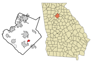
mapsize = 250x200px
map_caption = Location in Gwinnett County and the state of Georgia
mapsize1 =
map_caption1 =
image_dot_
dot_mapsize =
dot_map_caption =
dot_x =
dot_y =
pushpin_
pushpin_label_position =
pushpin_map_caption =
pushpin_mapsize =
subdivision_type = Country
subdivision_name =United States
subdivision_type1 = State
subdivision_name1 = Georgia
subdivision_type2 = County
subdivision_name2 = Gwinnett
subdivision_type3 =
subdivision_name3 =
subdivision_type4 =
subdivision_name4 =
government_footnotes =
government_type =
leader_title =
leader_name =
leader_title1 =
leader_name1 =
leader_title2 =
leader_name2 =
leader_title3 =
leader_name3 =
leader_title4 =
leader_name4 =
established_title =
established_date =
established_title2 =
established_date2 =
established_title3 =
established_date3 =
area_magnitude =
unit_pref = Imperial
area_footnotes =
area_total_km2 = 4.5
area_land_km2 = 4.5
area_water_km2 = 0
area_total_sq_mi = 1.8
area_land_sq_mi = 1.8
area_water_sq_mi = 0
area_water_percent =
area_urban_km2 =
area_urban_sq_mi =
area_metro_km2 =
area_metro_sq_mi =
area_blank1_title =
area_blank1_km2 =
area_blank1_sq_mi =
population_as_of = 2000
population_footnotes =
population_note =
population_total = 765
population_density_km2 = 170
population_density_sq_mi = 425
population_metro =
population_density_metro_km2 =
population_density_metro_sq_mi =
population_urban =
population_density_urban_km2 =
population_density_urban_sq_mi =
population_blank1_title =
population_blank1 =
population_density_blank1_km2 =
population_density_blank1_sq_mi =
timezone = Eastern (EST)
utc_offset = -5
timezone_DST = EDT
utc_offset_DST = -4
latd = 33 |latm = 53 |lats = 36 |latNS = N
longd = 83 |longm = 57 |longs = 20 |longEW = W
elevation_footnotes =
elevation_m = 334
elevation_ft = 1096
postal_code_type =ZIP code
postal_code = 30017
area_code = 770
blank_name = FIPS code
blank_info = 13-34596GR|2
blank1_name = GNIS feature ID
blank1_info = 0314805GR|3
website =
footnotes =Grayson is a city in Gwinnett County, Georgia,
United States . The population was 765 at the 2000 census.Geography
Grayson is located at coor dms|33|53|36|N|83|57|20|W|city (33.893306, -83.955420)GR|1.According to the
United States Census Bureau , the city has a total area of 1.8square mile s (4.6km² ), all of it land.Grayson suffered a damaging tornado on June 27, 1994, killing a 10-year-old girl. The city has been benefitting from exurban growth in eastern Gwinnett County, especially in the late 1990s and through the 2000s.Government
The city government of Grayson consists of a
mayor and four council members. The current mayor is Jim Hinkle, and the city council includes Jimmy Adams, Suzanne Hawkins, Tammy Shumate, and Allison Wilkerson. Other city officials include City Administrator Laura Paul-Cone, City Historian Steven Starling, and Art & History Center Director Barbra Hinkle.Demographics
As of the
census GR|2 of 2000, there were 765 people, 276 households, and 226 families residing in the city. Thepopulation density was 435.8 people per square mile (167.8/km²). There were 288 housing units at an average density of 164.1/sq mi (63.2/km²). The racial makeup of the city was 94.77% White, 3.53% African American, 0.39% Asian, 0.65% Pacific Islander, 0.26% from other races, and 0.39% from two or more races. Hispanic or Latino of any race were 0.92% of the population.There were 276 households out of which 44.6% had children under the age of 18 living with them, 68.1% were married couples living together, 9.1% had a female householder with no husband present, and 17.8% were non-families. 15.2% of all households were made up of individuals and 7.6% had someone living alone who was 65 years of age or older. The average household size was 2.77 and the average family size was 3.02.
In the city the population was spread out with 29.5% under the age of 18, 4.6% from 18 to 24, 34.0% from 25 to 44, 22.5% from 45 to 64, and 9.4% who were 65 years of age or older. The median age was 35 years. For every 100 females there were 99.7 males. For every 100 females age 18 and over, there were 91.8 males.
The median income for a household in the city was $51,750, and the median income for a family was $61,618. Males had a median income of $37,500 versus $36,250 for females. The
per capita income for the city was $22,695. About 6.3% of families and 8.2% of the population were below thepoverty line , including 5.2% of those under age 18 and 13.6% of those age 65 or over.Grayson Day
Modeled after Snellville Days in nearby
Snellville , Grayson Day, held annually on a Saturday at the end of April, features a parade down Main Street, food vendors, crafts, and live music. The city and local businesses sponsor the event, which takes place mostly in the centrally located Grayson City Park. The football team, marching band, and cheerleaders from Grayson High School, as well as other local organizations, politicians, and groups make the parade a favorite tradition among residents.Useful Info
The City of Grayson and its surrounding community is in Gwinnett County, GA. It is found on the Southeastern portion of the county. It is in between the cities of Loganville, Lawrencville, Snellville and Dacula.
History
* The first settlers came into an area what is now Grayson in 1820
* The town of Grayson was founded in 1879 by James Patterson McConnell. He purchased 80 acres of land from his uncle Stephen Billue and that became part of the town.
* On April 5, 1881 McConnell built a building which consisted of the first post office and held other companies. J.D. Spence, a merchant and public figure in Lawrenceville, a nearby city, named the area “Trip” because it was a “trip” to McConnell’s country store. McConnell began clearing land and building homes to make the area more attractive. Trip was once called the Garden Spot of Gwinnett County. The first residences included the families of the Billues, McConnells, Jacobs, Carroll, Cates, Rawlins, Petty, Kennerly, Ford, Gower, Hawthrone, Cooper, Tribble, and Chandler.
* By the end of 1907, the town of Trip was an official incorporated town called Grayson.
* In 1951, natural gas and electricity began running through the area. Therefore gas stoves came into peoples homes. According to Steve Starling, an official historian of the city of Grayson who contributed to “Historic Grayson, Georgia” wrote, “The Southern part of Gwinnett County was formed on either end of what is now considered Grayson. The New Hope, or Tribble's Mill, area and the Haynes Creek, or Midway Area, were thriving settlements in the early to middle nineteenth century. Prior to these settlements the Creek Indians has lived on this land.”History of the Name
The city of Grayson was first called Trip. In 1901, John Ellery Jacobs, the postmaster and civic leader, wrote to the post office department requesting that Trip, Georgia be changed to Berkley, Georgia. On December 6, 1901, the General Assembly of Georgia approved an act to incorporate the town and change the name. Shortly after, Ellery Jacobs was notified that there was already a Berkley, Georgia. He then suggested Graymount (because there was a clear view of Stone Mountain) but it was also taken. Mr. Jacobs' wife, Ada McConnell Jacobs, was visiting a county in Texas called Grayson and then suggested the name.
People
* Geraldine Copper (1906-1997) -- lived on Main Street in Grayson; started teaching after graduating from the from the high school in 1923; she taught at Centerville, Bethel, Grayson, Ivy Creek, Lakewood Heights, Snellville and Lawrenceville.
* Doug Wilkerson -- served as mayor for several terms in the 1970s;
* Ponnie More -- granddaughter of J.P. McConnell;
* Alexander Webb (uncle Elec) -- was married to Cora Copper Webb and was son of Rev. A.J. Webb (owned Webb's cotton Gin House);
* Bill Farmer -- graduated Barber school in 1959 and began cutting hair; 1965 he built a building at the corner of highway 20 and Grayson Parkway - he then sold it to Ms. Janice; he then built his barber shop on Pine Grove Ave in front of his house where he continued cutting hair till he retired in 1988. His building was moved to the grounds of the Art and Historic Center for preservation.
* Cliff Tribble -- was a member of the Grayson Cornet Band which performed all over the county in the 1900s.References
External links
Wikimedia Foundation. 2010.