- Copley, County Durham
-
Coordinates: 54°37′19″N 1°52′01″W / 54.622°N 1.867°W
Copley 
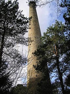
Copley Chimney, built in 1832
as part of the Gaunless lead Mill
 Copley shown within County Durham
OS grid reference NZ086252 Shire county County Durham Region North East Country England Sovereign state United Kingdom Post town DARLINGTON Postcode district DL13 Police Durham Fire County Durham and Darlington Ambulance North East EU Parliament North East England List of places: UK • England • County Durham Copley is a village in County Durham, in England. It is situated 9 miles to the west of Bishop Auckland, and 6 miles from the historic market town of Barnard Castle. It is an attractive rural setting close to the North Pennines AONB.
Copley has its own official weather station (http://www.kencook.magix.net) run by the Met Office and Environment Agency. Because of its height above sea-level, around the 1,000ft contour, and position in the north-east, this station is often one of the coldest in England with high incidences of ground frosts and snowfalls. Copley's situation in north-east England also places it in a relatively dry and sunny rain-shadow area in the shelter of the higher Pennines to the west. However, the higher Pennines can also create a local strong and gusty effect if the wind blows from the west-south-west. This is called the Pennine Lee Wave and can appear suddenly and disappear just as quickly.
References
External links
Categories:- County Durham geography stubs
- Villages in County Durham
Wikimedia Foundation. 2010.

