- Punta Rassa, Florida
Infobox Settlement
official_name = Punta Rassa, Florida
other_name =
native_name =
nickname =
settlement_type = CDP
motto =
imagesize =
image_caption =
flag_size =
image_
seal_size =
image_shield =
shield_size =
image_blank_emblem =
blank_emblem_type =
blank_emblem_size =
imagesize =
image_caption =
flag_size =
image_
seal_size =
image_shield =
shield_size =
image_blank_emblem =
blank_emblem_type =
blank_emblem_size =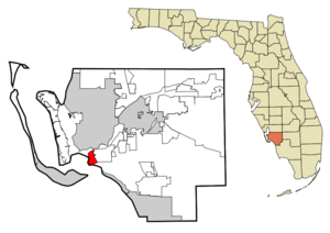
mapsize = 250x200px
map_caption = Location in Lee County and the state ofFlorida
mapsize1 =
map_caption1 =
image_dot_
dot_mapsize =
dot_map_caption =
dot_x =
dot_y =
pushpin_
pushpin_label_position =
pushpin_map_caption =
pushpin_mapsize =
subdivision_type = Country
subdivision_name = flag|United States
subdivision_type1 = State
subdivision_name1 = flag|Florida
subdivision_type2 = County
subdivision_name2 = noflag|Lee
subdivision_type3 =
subdivision_name3 =
subdivision_type4 =
subdivision_name4 =
government_footnotes =
government_type =
leader_title =
leader_name =
leader_title1 =
leader_name1 =
leader_title2 =
leader_name2 =
leader_title3 =
leader_name3 =
leader_title4 =
leader_name4 =
established_title =
established_date =
established_title2 =
established_date2 =
established_title3 =
established_date3 =
area_magnitude =
unit_pref = Imperial
area_footnotes =
area_total_km2 = 11.6
area_land_km2 = 6.1
area_water_km2 = 5.5
area_total_sq_mi = 4.5
area_land_sq_mi = 2.4
area_water_sq_mi = 2.1
area_water_percent =
area_urban_km2 =
area_urban_sq_mi =
area_metro_km2 =
area_metro_sq_mi =
area_blank1_title =
area_blank1_km2 =
area_blank1_sq_mi =
population_as_of = 2000
population_footnotes =
population_note =
population_total = 1731
population_density_km2 = 149.2
population_density_sq_mi = 384.7
population_metro =
population_density_metro_km2 =
population_density_metro_sq_mi =
population_urban =
population_density_urban_km2 =
population_density_urban_sq_mi =
population_blank1_title =
population_blank1 =
population_density_blank1_km2 =
population_density_blank1_sq_mi =
timezone = Eastern (EST)
utc_offset = -5
timezone_DST = EDT
utc_offset_DST = -4
latd = 26 |latm = 30 |lats = 38 |latNS = N
longd = 81 |longm = 59 |longs = 56 |longEW = W
elevation_footnotes =
elevation_m = 1
elevation_ft = 3
postal_code_type =
postal_code =
area_code =
blank_name = FIPS code
blank_info = 12-59250GR|2
blank1_name = GNIS feature ID
blank1_info = 0289383GR|3
website =
footnotes =Punta Rassa is a
census-designated place (CDP) in Lee County,Florida ,United States . The population was 1,731 at the 2000 census.Geography
Punta Rassa is located at coor dms|26|30|38|N|81|59|56|W|city (26.510444, -81.998808)GR|1.
According to the
United States Census Bureau , the CDP has a total area of 4.5square mile s (11.6km² ), of which, 2.4 square miles (6.1 km²) of it is land and 2.1 square miles (5.5 km²) of it (47.66%) is water.History
Punta Rassa was an important cattle town in the 1800's, being the point where Florida's "crackers" would drive their cattle to ship to Cuba. The spot figured prominently in the historical novel "A Land Remembered." It also held the telegraph office that first learned of the sinking of the U.S.S. Maine in Cuba.
Demographics
As of the
census GR|2 of 2000, there were 1,731 people, 1,015 households, and 481 families residing in the CDP. Thepopulation density was 734.8 people per square mile (283.2/km²). There were 1,372 housing units at an average density of 582.4/sq mi (224.5/km²). The racial makeup of the CDP was 99.25% White, 0.35% African American, 0.12% Native American, 0.17% Asian, 0.06% from other races, and 0.06% from two or more races. Hispanic or Latino of any race were 0.23% of the population.There were 1,015 households out of which 1.5% had children under the age of 18 living with them, 46.7% were married couples living together, 0.5% had a female householder with no husband present, and 52.6% were non-families. 52.0% of all households were made up of individuals and 48.7% had someone living alone who was 65 years of age or older. The average household size was 1.53 and the average family size was 2.09.
In the CDP the population was spread out with 1.5% under the age of 18, 0.5% from 18 to 24, 2.8% from 25 to 44, 12.8% from 45 to 64, and 82.5% who were 65 years of age or older. The median age was 80 years. For every 100 females there were 63.9 males. For every 100 females age 18 and over, there were 64.3 males.
The median income for a household in the CDP was $44,583, and the median income for a family was $66,912. Males had a median income of $73,333 versus $19,583 for females. The
per capita income for the CDP was $39,048. None of the families and 1.9% of the population were living below thepoverty line , including no under eighteens and 1.3% of those over 64.References
External links
Wikimedia Foundation. 2010.