- 1948 Atlantic hurricane season
Infobox hurricane season | name=1948 Atlantic hurricane season
first storm formed=May 22, 1948
last storm dissipated=November 11, 1948
strongest storm=#6, 8 - 115 knots (135 mph, 220 km/h) #7 - 963 mbar
total storms=9
major storms=4
total da
(1948USD )
total fatalities=94
basin=Atlantic hurricane
five seasons=1946, 1947, 1948, 1949, 1950 The 1948 Atlantic hurricane season officially began on June 15, 1948, and lasted until November 15, 1948. [Associated Press . [http://www.thehurricanearchive.com/Viewer.aspx?] Retrieved on
2008-06-06 .] These dates conventionally delimit the period of each year when mosttropical cyclone s form in theAtlantic basin .The 1948 Atlantic hurricane season featured nine tropical cyclones; six storms attained hurricane status, and four storms intensified to major hurricanes with winds of at least Category 3 intensity. Operationally, ten tropical disturbances were noted; a weak tropical disturbance formed over the southeast Bahamas in May and moved northwest into the Georgia coast near Savannah, producing winds of 30 mph (48 km/h).
eason summary
The 1948 Atlantic hurricane season was slightly below average, and it featured a total of nine storms, which fell below the climatological seasonal average of ten. All of the hurricanes formed during the latter half of the season, and the number of intense hurricanes surpassed the average of two.cite web|author=Unisys|title=1948 Atlantic tropical cyclone data|accessdate=2007-06-09|url=http://weather.unisys.com/hurricane/atlantic/1948/index.html] The season featured one tropical storm in May, and it was among eighteen tropical systems which formed during that month in the
Atlantic basin . Of the ten tropical disturbances detected operationally, five struck the United States with winds of 39 mph (60 km/h) or greater, while the other tropical systems affected islands, remained over the open ocean, or affected the country with winds below tropical storm intensity. Three hurricanes made landfall in the United States, while the three other storms with winds of at least 74 mph (120 km/h) largely remained at sea.The strongest storms of the season attained Category 4 intensity; two of the major hurricanes formed in the western
Caribbean Sea and affected the United States in late September and October. A minimal hurricane struck southernLouisiana , causing tides of five feet and winds of 78 mph (125 km/h) in New Orleans. A minimal tropical storm made landfall near Destin in July. An intense hurricane attained Category 4 strength and produced extensive damage and 100 mph (160 km/h) wind gusts onBermuda in mid-September. A Category 3 hurricane struck the southern portion of Florida, resulting in $12 million of damages in the state. After the passage of one week, another hurricane affected the region as a Category 2 storm, after crossingCuba with winds of 135 mph (220 km/h). Only three direct fatalities occurred in theUnited States , largely because of improved evacuations and adherence to warnings and advisories.cite web|author=H. C. Sumner|year=1948|title=North Atlantic Hurricanes and Tropical Disturbances of 1948|publisher=U.S. Weather Bureau|accessdate=2007-04-12|url=http://docs.lib.noaa.gov/rescue/mwr/076/mwr-076-12-0277.pdf]torms
Tropical Storm One
infobox hurricane small
name=Tropical Storm One
category=storm
type=tropical storm
formed=May 22
dissipated=May 28, 1948
highest winds=50 mph (80 km/h)
pressure=UnknownTen days preceding the start of the season, a broad area of low pressure in the centralCaribbean Sea developed into a weak tropical storm early on May 22. The circulation moved northeast, and it made landfall in southwestHaiti with winds of 40 mph (60 km/h) during the morning hours. The system crossed the island and maintained its intensity as it entered the southwest Atlantic. On May 24, the tropical cyclone slowly intensified, and it began to gradually turn to the north. Within a few hours, the storm attained its estimated peak intensity of 50 mph (80 km/h), as reported by reconnaissance aircraft.cite web|author=H. C. Sumner|year=1948|title=North Atlantic Hurricanes and Tropical Disturbances of 1948|publisher=U.S. Weather Bureau|accessdate=2007-04-12|url=http://docs.lib.noaa.gov/rescue/mwr/076/mwr-076-12-0277.pdf] On May 25, the storm's forward motion slowed to a crawl, and the cyclone started to weaken on May 26. On May 27, the system began to accelerate northward, and it gained extratropical characteristics. The system diminished to a tropical depression on May 28 shortly prior to dissipation convert|800|mi|km east ofDelaware .cite web|author=Unisys|title=1948 Atlantic tropical cyclone data|accessdate=2007-06-09|url=http://weather.unisys.com/hurricane/atlantic/1948/index.html]The tropical system brought widespread precipitation to Hispaniola, and widespread flooding took place across the region. 80 people died during the events, though other impacts are unknown, however this storm still ranks as the deadliest Atlantic storm to form in the off-season.cite web|author=H. C. Sumner|year=1948|title=North Atlantic Hurricanes and Tropical Disturbances of 1948|publisher=U.S. Weather Bureau|accessdate=2007-04-12|url=http://docs.lib.noaa.gov/rescue/mwr/076/mwr-076-12-0277.pdf]
Tropical Storm Two
infobox hurricane small
name=Tropical Storm Two
category=storm
type=tropical storm
formed=July 7
dissipated=July 11, 1948
highest winds=40 mph (65 km/h)
pressure=UnknownAfter nearly two months of inactivity, an area of disturbed weather developed in the northernGulf of Mexico . The area organized to a 40 mph (65 km/h) tropical storm on July 11, and the system maintained its intensity as it moved to the northeast on July 8. The weak tropical system made landfall east of Pensacola on July 9, and it quickly weakened to a depression as it moved inland. The remnants moved north through southeasternAlabama on July 10, and the circulation dissipated over southernTennessee on July 11.cite web|author=Unisys|title=1948 Atlantic tropical cyclone data|accessdate=2007-06-09|url=http://weather.unisys.com/hurricane/atlantic/1948/index.html]The system produced minimal effects along the
Florida Panhandle . Winds of 35 mph (55 km/h) were measured at Pensacola during the passage of athunderstorm , and the tropical cyclone caused heavy precipitation over northernFlorida , southern Alabama, and southern Georgia. Overall damage was minimal.cite web|author=H. C. Sumner|year=1948|title=North Atlantic Hurricanes and Tropical Disturbances of 1948|publisher=U.S. Weather Bureau|accessdate=2007-04-12|url=http://docs.lib.noaa.gov/rescue/mwr/076/mwr-076-12-0277.pdf]Hurricane Three
infobox hurricane small
name=Hurricane Three
category=cat3
type=hurricane
formed=August 26
dissipated=September 4, 1948
highest winds=120 mph (195 km/h)
pressure=UnknownAfter one month of inactivity, the first hurricane of the season formed in late August. A 60 mph (95 km/h) tropical storm formed on August 26 600 miles northeast of Saint John, as ship reports indicated winds of Force 9. The tropical cyclone quickly intensified to a hurricane, and it continued to steadily progress northwest. The storm strengthened to a Category 2 hurricane on August 27, and it continued to intensify until it attained its estimated peak intensity of 120 mph (195 km/h) on August 28.cite web|author=H. C. Sumner|year=1948|title=North Atlantic Hurricanes and Tropical Disturbances of 1948|publisher=U.S. Weather Bureau|accessdate=2007-04-12|url=http://docs.lib.noaa.gov/rescue/mwr/076/mwr-076-12-0277.pdf] Its forward motion slowed on August 29, and it began to weaken as it turned to the north convert|250|mi|km south of Hatteras on August 30. The tropical system weakened to a minimal hurricane, and it accelerated to the northeast on August 31. The storm soon became extratropical, and the remnants dissipated east of southernGreenland on September 4.cite web|author=Unisys|title=1948 Atlantic tropical cyclone data|accessdate=2007-06-09|url=http://weather.unisys.com/hurricane/atlantic/1948/index.html]In anticipation of the storm, the U.S. Weather Bureau posted hurricane warnings from Wilmington to
Cape Hatteras .cite web|author=Warren Times-Mirror|year=1948|title=Storm Moving Up Coast May Miss The Mainland Entirely|publisher=The Associated Press|accessdate=2007-06-09|url=http://www.thehurricanearchive.com/Viewer.aspx?] On August 30, as the tropical cyclone began to turn to the north, the center was expected to pass over or near Cape Hatteras.cite web|author=The Progress|year=1948|title=Late News Flashes|publisher=The Associated Press|accessdate=2007-06-09|url=http://www.thehurricanearchive.com/Viewer.aspx?
] The hurricane caused high tides on the
North Carolina coastline, which prompted evacuations and precautions in the area. No damages or fatalities were reported.cite web|author=H. C. Sumner|year=1948|title=North Atlantic Hurricanes and Tropical Disturbances of 1948|publisher=U.S. Weather Bureau|accessdate=2007-04-12|url=http://docs.lib.noaa.gov/rescue/mwr/076/mwr-076-12-0277.pdf]Tropical Storm Four
infobox hurricane small
name=Tropical Storm Four
category=storm
type=tropical storm
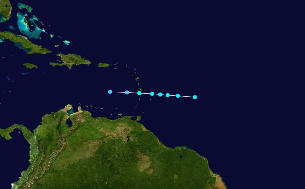
formed=August 31
dissipated=September 1, 1948
highest winds=60 mph (95 km/h)
lowest pressure=1007mbar The season's activity increased during late August. Four days after the formation of Hurricane Three, a 60 mph (95 km/h) tropical storm was detected on August 30 convert|450|mi|km east ofSaint Lucia , as a ship reported high easterly seas and winds of Force 10. The small system moved steadily to the west, and it slowly weakened to a marginal tropical cyclone on August 31. On the morning of September 1, the circulation passed between Saint Lucia andMartinique , when a reconnaissance aircraft mission reported a minimum pressure of 1007 mbar (29.73 inHg).cite web|author=Unisys|title=1948 Atlantic tropical cyclone data|accessdate=2007-06-09|url=http://weather.unisys.com/hurricane/atlantic/1948/index.html] Subsequent missions failed to detect a center of circulation, and the tropical cyclone quickly degenerated to a tropical depression. It dissipated over the easternCaribbean Sea .cite web|author=H. C. Sumner|year=1948|title=North Atlantic Hurricanes and Tropical Disturbances of 1948|publisher=U.S. Weather Bureau|accessdate=2007-04-12|url=http://docs.lib.noaa.gov/rescue/mwr/076/mwr-076-12-0277.pdf]The short-lived tropical storm resulted in no reports of damages, and heavy precipitation affected the islands. The rainfall was beneficial, notably in
Puerto Rico ; water supplies and crops were replenished. Minor flooding occurred on the islands and caused minimal damage.cite web|author=H. C. Sumner|year=1948|title=North Atlantic Hurricanes and Tropical Disturbances of 1948|publisher=U.S. Weather Bureau|accessdate=2007-04-12|url=http://docs.lib.noaa.gov/rescue/mwr/076/mwr-076-12-0277.pdf]Hurricane Five
infobox hurricane small
name=Hurricane Five
category=cat1
type=hurricane
formed=September 1
dissipated=September 7, 1948
highest winds=80 mph (130 km/h)
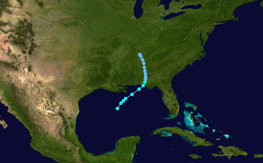
lowest pressure=989mbar As the peak of hurricane season arrived, an area of disturbed weather organized to a 39 mph (63 km/h) tropical storm on September 1 over the southernGulf of Mexico . On the morning of September 2, the poorly defined center moved northeast, and the tropical cyclone gradually intensified.cite web|author=Unisys|title=1948 Atlantic tropical cyclone data|accessdate=2007-06-09|url=http://weather.unisys.com/hurricane/atlantic/1948/index.html] It attained hurricane intensity on September 3, and it slowly accelerated toward the upper Gulf Coast. It rapidly reached its peak intensity of 80 mph (130 km/h), and it crossed the coastline near Grand Isle around midnight on September 4. The center moved inland over Orleans Parish, and the weakening tropical cyclone diminished to a strong tropical storm prior to moving over southernMississippi . It continued to weaken as it approached Hattiesburg on September 5, and it moved over the area with winds of 40 mph (65 km/h). The remnants turned to the north, and the circulation dissipated over northwesternIndiana on September 6.cite web|author=H. C. Sumner|year=1948|title=North Atlantic Hurricanes and Tropical Disturbances of 1948|publisher=U.S. Weather Bureau|accessdate=2007-04-12|url=http://docs.lib.noaa.gov/rescue/mwr/076/mwr-076-12-0277.pdf]On September 4, the U.S. Weather Bureau advised residents that the storm was expected to strike land between Morgan City and Grand Isle around midnight, as its forward motion had increased to 15 mph (25 km/h).cite web|author=Kingsport News|year=1948|title=Louisiana Battens Down as Hurricane Nears Coast|publisher=The Associated Press|accessdate=2007-07-01|url=http://www.thehurricanearchive.com/Viewer.aspx?
] The weather service also noted that abnormally high tides were expected from the
Mississippi River to Pensacola, as the center was predicted to pass east of New Orleans and move to the west of Biloxi shortly before dawn. 1,000 people left their homes in Terrebonne Parish and took shelter in a courthouse and school buildings in Houma. As winds increased, city officials in New Orleans ordered 2,000 people to evacuate from a wartime housing project into an auditorium for shelter.cite web|author=The Daily Messenger|year=1948|title=Thousands Flee Gulf Coast|publisher=The Associated Press|accessdate=2007-07-01|url=http://www.thehurricanearchive.com/Viewer.aspx?] The hurricane produced gusts of 78 mph (125 km/h) at Moisant Airport, and tides ranged from 6 to convert|3.4|ft|m along the coast from Mississippi to the
Florida Panhandle . The maximum tide reached convert|4.7|ft|m in New Orleans, and winds caused damage to small boats, trees, and power and communication lines. At Grand Isle, the heaviest damage occurred to oil rigs and drilling equipment from high tides. Total damage in the United States reached $900,000, but no loss of life was reported.cite web|author=H. C. Sumner|year=1948|title=North Atlantic Hurricanes and Tropical Disturbances of 1948|publisher=U.S. Weather Bureau|accessdate=2007-04-12|url=http://docs.lib.noaa.gov/rescue/mwr/076/mwr-076-12-0277.pdf]Hurricane Six
infobox hurricane small
name=Hurricane Six
category=cat4
type=hurricane

formed=September 4
dissipated=September 16, 1948
highest winds=135 mph (220 km/h)
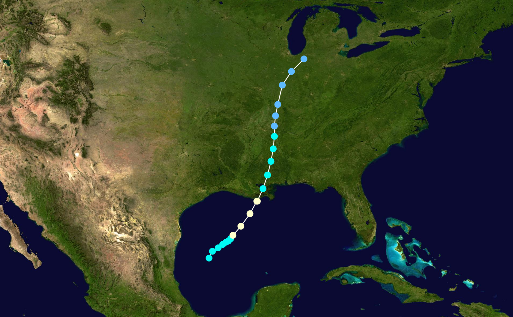
pressure=UnknownStorm Six was aCape Verde-type hurricane that formed from a tropical wave off Africa on September 3 and rapidly strengthened into a hurricane. It moved steadily west-northwest across the Atlantic, gradually strengthening. The storm became a major hurricane while northeast of theWindward Islands . It began to make a broad curve to the north over a three-day period. During that period, the storm continued to strengthen, peaking at Category 4 strength with winds of 135 mph (220 km/h). Shortly after, the hurricane passed almost directly over Bermuda, bringing 100+ mph (160 km/h) winds to the island. Damage was heavy but no figures currently exist. No people are known to have died. The hurricane continued north and curved gently to the northeast, passing south ofCape Race, Newfoundland before becoming extratropical.Hurricane Seven
infobox hurricane small
name=Hurricane Seven
category=cat3
type=hurricane

track=1948 Atlantic hurricane 7 track.png
dissipated=September 25, 1948
highest winds=120 mph (195 km/h)
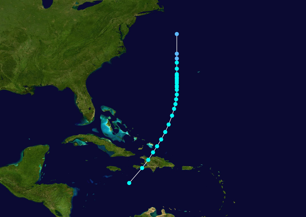
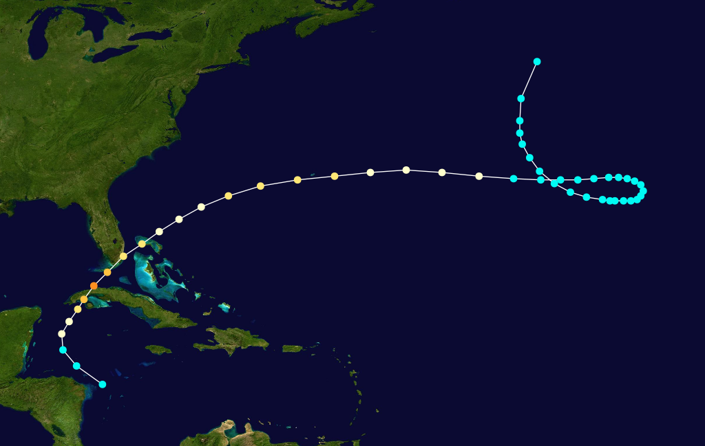
lowest pressure=963mbar Caribbean Sea developed into a tropical storm on September 18. It moved northwestward, hittingCuba south ofHavana on September 20. It strengthened to a major hurricane the next day, hit theFlorida Keys , and made landfall near Everglades City, Florida on September 21. It weakened over Florida, and turned northeast, becoming extratropical on September 24. The hurricane was responsible for $12 million in damage (1948 dollars) and 3 deaths in Florida and 10 deaths and "several million dollars" in damage in Cuba.Hurricane Eight
infobox hurricane small
name=Hurricane Eight
category=cat4
type=hurricane
formed=October 3
dissipated=October 16, 1948
highest winds=135 mph (220 km/h)
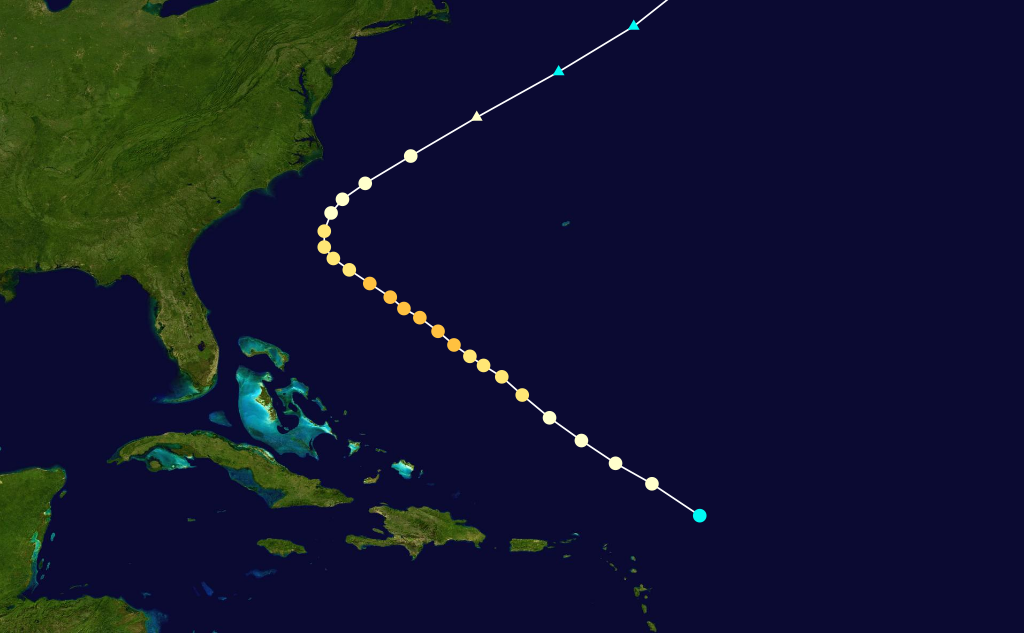
lowest pressure=975mbar A tropical storm formed in the Western Caribbean Sea on October 3. It turned northward, hitting western Cuba on October 5 as a major hurricane, an area recently affected by the previous hurricane two weeks ago. It continued northeastward, reaching a peak of 135 mph (220 km/h) winds before hitting the Florida Keys and southwestFlorida on October 5 and early on October 6. Weakening over land, the hurricane passed just south of Bermuda, weakened to a tropical storm, looped northward, and dissipated on October 16. The hurricane caused $11 million in damage (1948 dollars) and 11 casualties.Hurricane Nine
infobox hurricane small
name=Hurricane Nine
category=cat1
type=hurricane
formed=November 8
dissipated=November 11, 1948
highest winds=80 mph (130 km/h)
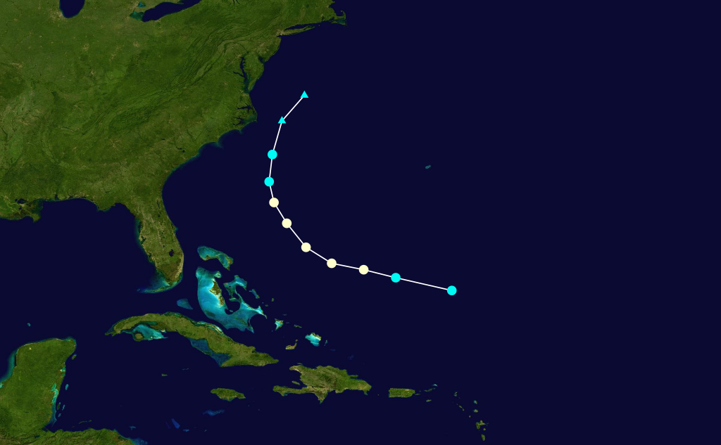
pressure=UnknownThe final storm of the season formed in early November over the open ocean southwest of Bermuda and made a curve to the north while slowly strengthening. The storm peaked with convert|80|mi/h|km/h|abbr=on winds before the center began to fall apart. The weakening storm passed by theOuter Banks with minimal effects before degenerating into a squall line off theVirginia coast early on November 11.Accumulated Cyclone Energy (ACE) rating
The table on the right shows the ACE for each storm in the season. ACE is, broadly speaking, a measure of the power of the hurricane multiplied by the length of time it existed, so storms that last a long time, as well as particularly strong hurricanes, have high ACEs. ACE is only officially released for full advisories on tropical systems at or exceeding 34 knots (39 mph, 63 km/h) or tropical storm strength. Subtropical storms are not included in season totals.
See also
*
List of tropical cyclones
*List of Atlantic hurricane seasons References
External links
* [http://www.aoml.noaa.gov/general/lib/lib1/nhclib/mwreviews/1948.pdf 1948 Monthly Weather Review]

Wikimedia Foundation. 2010.