- Kwigillingok Airport
-
Kwigillingok Airport 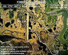
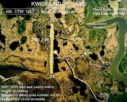
IATA: KWK – ICAO: PAGG – FAA LID: GGV Summary Airport type Public Owner State of Alaska DOT&PF - Central Region Location Kwigillingok, Alaska Elevation AMSL 18 ft / 5 m Coordinates 59°52′35″N 163°10′07″W / 59.87639°N 163.16861°WCoordinates: 59°52′35″N 163°10′07″W / 59.87639°N 163.16861°W Runways Direction Length Surface ft m 15/33 2,510 765 Gravel Source: Federal Aviation Administration[1] Kwigillingok Airport (IATA: KWK, ICAO: PAGG, FAA LID: GGV, formerly A85) is a state-owned, public-use airport located one mile (two kilometres) northwest of the central business district of Kwigillingok, in the Bethel Census Area of the U.S. state of Alaska.[1] There is also a nearby seaplane landing area known as Kwigillingok Seaplane Base (FAA LID: KWK).[2]
Although most U.S. airports use the same three-letter location identifier for the Federal Aviation Administration and International Air Transport Association, the airport is assigned GGV by the FAA[3] and KWK by the IATA .[4]
Contents
Facilities
The airport has one gravel runway (15/33) measuring 2,510 x 60 ft. (765 x 18 m).[1]
Airlines and destinations
- Hageland Aviation Services (Bethel, Kipnuk, Kongiganak)[5]
See also
References
- ^ a b c FAA Airport Master Record for GGV (Form 5010 PDF), effective July 5, 2007.
- ^ FAA Airport Master Record for KWK (Form 5010 PDF), effective July 5, 2007.
- ^ Great Circle Mapper: PAGG - Kwigillingok, Alaska
- ^ Aviation Safety Network: KWK - Kwigillingok Airport
- ^ Hageland Aviation Services: Scheduled Flights (PDF). Retrieved August 29, 2007.
External links
- FAA Alaska airport diagram (GIF)
- Resources for this airport:
- Airport information for PAGG at AirNav
- Aeronautical chart for GGV at SkyVector
- Accident history for KWK at Aviation Safety Network
Categories:- Airports in the Bethel Census Area, Alaska
- Alaska airport stubs
Wikimedia Foundation. 2010.