- Zhenbao Island
-
Coordinates: 46°29′08″N 133°50′40″E / 46.48556°N 133.84444°E
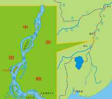
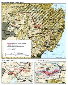
Zhenbao Island (simplified Chinese: 珍宝岛; traditional Chinese: 珍寶島; pinyin: Zhēnbǎo dǎo; literally "Rare Treasure Island") or Damansky Island (Russian: о́стров Дама́нский) is a small island measuring 0.74 square kilometres (0.29 sq mi). It is located on the Ussuri River on the border between Russia (Primorsky Krai) and the People's Republic of China (PRC) (Heilongjiang Province).
It was the subject of a territorial dispute between the Soviet Union and the PRC. Battles were fought over Zhenbao Island by the Soviet Union and the PRC, with a considerable loss of life, during the Sino-Soviet border conflict of March 1969. The conflict over Zhenbao raised concerns that it could ignite another World War until an initial resolution of the conflict in November, 1969.
On May 19, 1991, the two sides came to an agreement that Zhenbao Island was part of the territory of the PRC, and in accordance therewith, the Soviet Troops withdrew.
A 2004 Russian documentary film, Damansky Island Year 1969. ("Остров Даманский. 1969 год"), was made about the 1969 Zhenbao incident. Interviews were filmed with participants and leaders from both sides of the conflict.
External links
- Centuries-old dispute became open combat during Cold War (archived webpage)
- Geo Coords: 46°29'8.13"N , 133°50'40.04"E. Google Earth File: [1] Google Maps satellite image: [2]
- Google Earth BBS article: [3]
- Damanski-Zhenbao website
Heilongjiang topics General Geography Cities • Greater Khingan mountain range • Lesser Khingan mountain range • Wanda Mountains • Huma River • Muling River • Naoli River • Songhua River • Nen River • Mudan River • Amur RiverEducation Visitor attractions Categories:- Heilongjiang geography stubs
- Islands of China
- Geography of Heilongjiang
- Territorial disputes of the People's Republic of China
- China–Russia border
- River islands
Wikimedia Foundation. 2010.


