- North Andaman Island
-
North Anda_man 
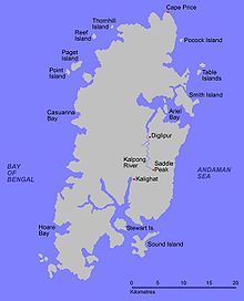
Map of North Andaman IslandGeography Location Bay of Bengal Coordinates 13°15′N 92°55′E / 13.25°N 92.917°E Archipelago Andaman Islands Area 1,375.99 km2 (531.273 sq mi) Highest elevation 738 m (2,421 ft) Highest point Saddle Peak Country IndiaIndian union territory Andaman and Nicobar Islands Indian district Andaman Largest city Diglipur (pop. 42,877) Demographics Ethnic groups Andamanese North Andaman Island is the northern island of Great Andaman of the Andaman Islands, with an area of 1376 km².[1] The main town on the island is Diglipur. Known for its marine life, the island's main industries are rice and orange-growing. The island is home to the highest point in the archipelago, Saddle Peak at 738 metres.
North Andaman experiences fairly frequent large earthquakes and suffered inundation from the 2004 Indian Ocean earthquake tsunami.
References
Coordinates: 13°15′N 92°55′E / 13.25°N 92.917°E
Categories:- Islands of the Andaman and Nicobar Islands
- Andaman and Nicobar geography stubs
Wikimedia Foundation. 2010.


