Middle Andaman Island

Middle Andaman Island
Middle Andaman

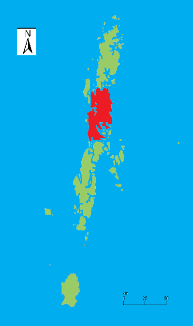
Outline map of the Andaman Islands, with the location of Middle Andaman Island highlighted (in red).
Middle Andaman Island is located in Burma
{{{alt}}}
Middle Andaman Island (off the coast of Burma)
Geography
Location Bay of Bengal
Coordinates 12°30′N 92°50′E / 12.5°N 92.833°E / 12.5; 92.833
Archipelago Andaman Islands
Area 1,535.5 km2 (592.86 sq mi)
Country
India
Indian union territory Andaman and Nicobar Islands
Indian district Andaman
Largest city Rangat (pop. 38,824)
Demographics
Ethnic groups Jarawa


Middle Andaman Island is the central island of the Great Andaman archipelago, with a total area of 1,536 km². Population of Middle Andaman consists of Bengali Settlers, Tamilians, and Keralites. The main occupation of the inhabitants is farming and Agriculture. The island is also home to many of the Jarawa people.

Its coastline was inundated by the tsunami resulting from the 2004 Indian Ocean earthquake (26th Dec), though the effect was far less severe when compared with other Islands of Andaman and Nicobar Islands.

Middle Andaman's main towns are Rangat, Billiground, Kadamtala, Bakultata and Betapur. the northern town Mayabunder, though geographically located on Middle Andaman, is administratively attached to North Andaman.

Coordinates: 12°30′N 92°50′E / 12.5°N 92.833°E / 12.5; 92.833


Wikimedia Foundation. 2010.

Игры ⚽ Поможем решить контрольную работу

Look at other dictionaries:

  • Middle Andaman Island — Vorlage:Infobox Insel/Wartung/Bild fehlt Middle Andaman Island Gewässer Indischer Ozean Inselgruppe Andamanen Geographische Lage …   Deutsch Wikipedia

  • Middle Button Island National Park — is an Indian national park located in the Andaman and Nicobar Islands. It is situated close to Point Blair. The total area that this parkland covers is about 64 square kilometres. Among the animals found here are the spotted deer …   Wikipedia

  • North Andaman Island — Karte von North Andaman Gewässer Indischer Ozean Inselgru …   Deutsch Wikipedia

  • South Andaman Island — Vorlage:Infobox Insel/Wartung/Bild fehlt South Andaman Island Gewässer Indischer Ozean Inselgruppe Andamanen Geographische Lage …   Deutsch Wikipedia

  • Middle Button Island National Park — Parc national de Middle Button Island Parc national de Middle Button Island Catégorie II de la CMAP (Parc national) Emplacement Andaman et Nicobar, Inde Superficie 64 km2 …   Wikipédia en Français

  • North and Middle Andaman district — is one of the 3 districts of the Indian Union Territory of Andaman and Nicobar Islands located in the Bay of Bengal. Mayabunder town is the district headquarters. The area covered by this district is 3251.85 km2. Contents 1 History 2… …   Wikipedia

  • Parc national de middle button island — Catégorie II de la CMAP (Parc national) Emplacement Andaman et Nicobar, Inde Superficie 64 km2 …   Wikipédia en Français

  • Parc national de Middle Button Island — Catégorie UICN II (parc national) Identifiant 9258 Pays   …   Wikipédia en Français

  • Andaman and Nicobar Islands — Andamanen und Nikobaren Status: Unionsterritorium Hauptstadt: Port Blair (121.000 Einwohner) Fläche: 8.249 km² Einwohner: 415.000 (2008) …   Deutsch Wikipedia

  • Andaman and Nicobar Islands — /nik euh bahr , nik euh bahr / a union territory of India, comprising the Andaman and Nicobar island groups in the E part of the Bay of Bengal, SW of Burma. 188,254; 3143 sq. mi. (8140 sq. km). Cap.: Port Blair. * * * Union territory (pop., 2001… …   Universalium

Share the article and excerpts

Direct link
Do a right-click on the link above
and select “Copy Link”