- Zona Río, Tijuana
Infobox Settlement
official_name = Zona Río Tijuana
native_name = Zona Río
nickname = El Río
motto =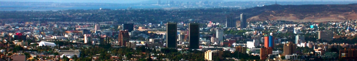
imagesize = 300px
image_caption = View of Tijuana skyline at Zona Rio
image_
image_shield =
mapsize =
map_caption =
pushpin_
subdivision_type =
subdivision_name =
subdivision_type1 = State
subdivision_name1 =
subdivision_type2 =Municipality
subdivision_name2 = Tijuana
subdivision_type3 =Borough
subdivision_name3 = Delegación Centro
government_type =
leader_title =
leader_name =
leader_title1 =
leader_name1 =
postal_code =
website =Zona Río is the
CBD area ofTijuana ,Baja California ,Mexico .Zona Río is located at a strategic point, at the north of the city, about 1
km from theU.S.-Mexico border , within the Centroborough , one of the main of Tijuana, and close toTijuana International Airport .Zona Río, as
CBD , is home for most of the commercial and financial businesses in the city, as well as the city's main health services. Banks, hotels, shopping squares, large public and private hospitals, restaurants, and many other businesses are based here, along Zona Río's three main avenues.Although being a relatively small
CBD in comparison with other Mexican cities of a similar size, such as those ofMonterrey and Guadalajara, Zona Río has some notable skyscrapers, which due to the relative distance between them, are easily seen as very tall. Actually, the tallest buildings are the the 28-storey twin towers that are home for the Plaza Aguacaliente and the [http://www.grandhoteltij.com.mx/english/index.html Grand Hotel Tijuana] , commonly known by locals as "Las Torres " (Spanish for The Towers).Name
Zona Río literally translates into English as River Zone, and this name is owned to the nearly-dried
Tijuana River , which divides Zona Río. The river is crossed by many bridges to allow traffic between the west side of Zona Río, located at the west-center of the city, and the east of Zona Rio, located in the east-center of Tijuana.Main avenues
Paseo de los Héroes Avenue
One of the most important avenues in the whole city of Tijuana, in English means Road of the Heroes. Along this avenue are located most of the financial, commercial, and touristic businesses of Zona Río and the entire city. Insurance companies, numerous banks, such as BBVA-Bancomer and Banamex, and shopping squares, such as [http://www.plazariotijuana.com.mx Plaza Río Tijuana] , the largest mall in the city, have their headquarters in this avenue. Also, the cultural heart-point of the city, the
Tijuana Cultural Center , is on Paseo de los Héroes. Two recently-built skyscrapers are exclusively occupied by two different hospitals and its corporations. Most of the high-end hotels of the entire city are located in Paseo de los Héroes avenue.Paseo de los Héroes is also noted for its many monuments and sculptures, like the "Monumento a la Raza" (Spanish for Monument to the Race), the
Abraham Lincoln statue, theIgnacio Zaragoza statue, theCuauhtémoc statue, theLázaro Cárdenas statue, and others, to which the avenue largely owes its name, Road of the Heroes.Tijuana CowParade 2008
During June
2008 , Tijuana hosts theCowParade . Along with the also popular Revolución Avenue, Paseo de los Héroes holds many of the artistic cows, in such popular places like the "Monumento a la Raza" and theTijuana Cultural Center .anchez Taboada Boulevard
In contrast to Paseo de los Heroes or Aguacaliente Boulevard, this is not one of the main avenues of the whole city, but rather only of Zona Río.
This avenue is the main gastronomical corridor of Zona Río, offering the widest variety of gastronomy in the entire city. There are restaurants offering food from
Thailand ,Mongolia ,Greece ,Brazil orIsrael , not to mention the typical Italian, Spanish, French, Argentinian, Chinese and American foods, plus the wide-spread Japanesesushi . As regards of Mexican food, the common tacos, Baja-seafood, and the "antojitos" (Spanish term for traditional Mexican food), they are found almost everywhere in the avenue.Aguacaliente Boulevard
This is one of the most important and largest avenues in the city, together with Paseo de los Héroes, with both crossing nearly the entire city.
Also one of the main gastronomical corridors in the city, and a touristic and commercial avenue, Aguacaliente Boulevard may be a combination of both Paseo de los Heroes and Sanchez Taboada Boulevard, but with a characteristic of being the place where sports auditoriums and stadiums are located.
The Aguacaliente
Hippodrome and Racetrack is located here. The Municipal Auditorium of Tijuana, home of both of Tijuana'sbasketball teams, and theEstadio Casas GeoCaliente Stadium, home of the city's newly formed soccer team.The tallest buildings of Tijuana, "
Las Torres ", are located here, along some other buildings and public hospitals.Paseo del Centenario Avenue
Paseo del Centenario (Spanish for Centennial Avenue) is also another important avenue within the area. The Municipal Palace of Tijuana is located here, along with the State Government Center of Tijuana.
New City Residential is located here, as well as the Tijuana General Hospital and many other notable buildings.Notable landmarks and places of interest
* Municipal Palace of Tijuana
*Tijuana Cultural Center
*Agua Caliente Casino and Hotel National Heritage Site
*Estadio Casas GeoCaliente and Caliente Hippodrome
*Plaza Rio Shopping Mall [ [http://www.plazariotijuana.com.mx Plaza Río Tijuana] ]Buildings and skyscrapers
*
Las Torres
*Green View Tower [ [http://www.greenviewtower.com Green View Tower] ]
*ING Comercial America Building
*Centro Médico Excel [es [http://www.hospitalexcel.com Centro Medico Excel] ] [ [http://www.emporis.com/en/wm/bu/?id=centromedicoexcel-tijuana-mexico Centro Médico Excel] onEmporis .]
*Hospital Angeles Tijuana
*Torre Platino [ [http://www.izabc.com/en/torre_platino.html Torre Platino] ] [ [http://www.keco.com.mx/desarrollos-plaza-corporativa-I.html Torre Platino - Plaza Corporativa I] ]
*Centura Tower
*Camino Real Hotel [ [http://www.caminoreal.com/tijuana/ Camino Real Tijuana] ]
*New City Residential
*Edificio GILT [ [http://www.emporis.com/en/wm/bu/?id=edificiogilt-tijuana-mexico Edificio GILT] onEmporis .]
*Centro de Control y Mando de Tijuana
*Edificio Ventura [ [http://www.emporis.com/en/wm/bu/?id=edificioventura-tijuana-mexico Edificio Ventura] onEmporis .]
*Torre Bellavista [ [http://www.emporis.com/en/wm/bu/?id=torrebellavista-tijuana-mexico Torre Bellavista] onEmporis .]
*Torre MOL [ [http://www.emporis.com/en/wm/bu/?id=torremol-tijuana-mexico Torre MOL] onEmporis .]
*VIA Corporativo [es [http://www.viacorporativo.com VIACorporativo] ] [ [http://www.el-mexicano.com.mx/nota.aspx?idNota=17660&esSecc=false VIA Corporativo, El primer edificio sustentable en Tijuana] from El Mexicano Online ]
*Hospital General de Tijuana
*Torre Zentrum [es [http://www.keco.com.mx/desarrollos_torre_zentrum.html Torre Zentrum] ]
*FRISA Building
*Wadiah Building
*Rodeo BuildingGallery
References
Wikimedia Foundation. 2010.