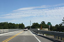
- Cut River Bridge
-
Cut River Bridge
The Cut River Bridge is a cantilevered steel deck bridgeCarries Pedestrians, automobiles, trucks Crosses Cut River ID number 49149023000B010 Design steel deck cantilever bridge Material Iron, structural steel, prestressed concrete Total length 641 feet (195 m) Constructed by W.J. Meager and Sons, Contractors Construction begin 1941 Construction end 1947 Opened 1947 Coordinates 46°02′42″N 85°07′31″W / 46.044986°N 85.125206°WCoordinates: 46°02′42″N 85°07′31″W / 46.044986°N 85.125206°W Cut River Bridge is a cantilevered steel deck bridge over the Cut River in the Upper Peninsula of the U.S. state of Michigan. It is located along U.S. Highway 2 (US 2) in Hendricks Township, Mackinac County,[1] between Epoufette and Brevort, about 25 miles (40 km) northwest of St. Ignace and the Straits of MackinacThere is a long but not often traversed wooden staircase to the valley below that was constructed some time after the construction of the bridge itself.
The bridge was built in 1947 and is one of only two cantilevered deck truss bridges in Michigan, it is 641 feet (195 m) long and contains 888 short tons (793 long tons; 806 t) of structural steel. The bridge carries traffic on US 2 above and spans the Cut River Valley, 147 feet (45 m) below.
Contents
History
The State Highway Department designed this structure, and W.J. Meager and Sons, Contractors, built it. Actual construction began in 1941. Due to the demand for steel during World War II, construction on the bridge was halted until after the war.
Construction
The bridge is a steel deck cantilever bridge. The structure has extensive latticing on its members, which are all very massive. The bridge retains original standard-plan metal guardrails on the sidewalks that flank the roadway on each side.
References
- ^ Michigan Department of Transportation (2009). Control Section/Physical Reference Atlas (Map). http://mdotwas1.mdot.state.mi.us/public/maps/pr/. Retrieved July 26, 2009.
- "31 Cut River Bridge". Michigan Department of Natural Resources. 2003. http://www.dnr.state.mi.us/publications/pdfs/wildlife/viewingguide/up/31CatRiver/index.htm. Retrieved September 26, 2010.
- "Cut River Bridge". Letterboxing North America. August 8, 2003. http://www.letterboxing.org/BoxView.php?boxnum=5232. Retrieved September 26, 2010.
- "Cut River Bridge". Historic Bridges of Michigan and Elsewhere. http://www.historicbridges.org/truss/us2/index.htm. Retrieved September 26, 2010.
- Hunt, Mary; Hunt, Don. "Epoufette: Cut River Bridge & Picnic Area". Hunts' Guide to Michigan's Upper Peninsula. Albion, MI: Midwestern Guides. http://hunts-upguide.com/epoufette_cut_river_bridge___picnic_area.html. Retrieved September 26, 2010.
- Hyde, Charles (May 13, 2002). "US 2 / Cut River". Historic Bridge Listing. Michigan Department of Transportation. http://www.michigan.gov/mdot/0,1607,7-151-9620_11154_11188-29665--,00.html. Retrieved September 26, 2010.
External links
 Media related to Cut River Bridge at Wikimedia CommonsCategories:
- Buildings and structures in Mackinac County, Michigan
- Bridges completed in 1947
- Beam bridges
- Truss bridges
- Transportation in Mackinac County, Michigan
- Road bridges in Michigan
Wikimedia Foundation. 2010.


