- Boyne River Bridge
Infobox Bridge
bridge_name = Boyne River Bridge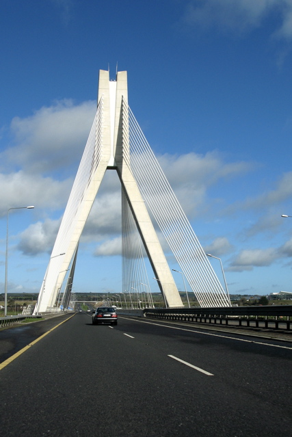
caption = M1 traffic crossing Boyne River Bridge
official_name =
carries = 4 lanes
crosses =Boyne River
locale = 3km west ofDrogheda
maint = Celtic Roads Group
id =
designer =Roughan & O'Donovan
design =cable-stayed bridge
material =
spans = 6
pierswater = 0
mainspan = 170m
length = 352.5m
width = 34.5m
height = 95m
load =
clearance = 20m
below =
traffic =
begin = 2000
complete = 2003
open =June 09 2003
closed =
toll =
map_cue =
map_
map_text =
map_width =
coordinates = coord|53.717866|N|6.396704|W
lat =
long =The Boyne River Bridge is the longest
cable-stayed bridge in Ireland. [ [http://news.bbc.co.uk/1/hi/northern_ireland/2974390.stm Bypass 'to cut journey times', BBC NEWS] ] It spans theBoyne River 3km west ofDrogheda and is part of the M1 Northern Motorway. (It will lose its status as the longest such bridge in the Republic in 2010 however, when theRiver Suir Bridge opens on the N25.) Due to environmental concerns, anEnvironmental Impact Statement (EIS) was carried out for the bridge separately from the M1 EIS -- the first such formal EIS carried out and published for a bridge in Ireland. [ [http://www.roughanodonovan.com/Publications/BOYNE%20BRIDGE%20PAPER%20030303.PDF The Design and Construction of the Boyne Bridge, page 4] ] In 2006 the bridge won the Excellence Award (Civil) from the Association of Consulting Engineers of Ireland. [ [http://www.acei.ie/boyne_bridge.asp ACEI Excellence Award (Civil) 2006] ] The bridge was built from 2000 to 2003 and was designed by Roughan and O’Donavan, who were awarded the ACEI Presidential Award in 2005 for the design. [ [http://www.acei.ie/roughanodonavan.asp ACEI Member News] ]Overview
Designing a road bridge over the Boyne was not an easy task. At the chosen point, three kilometers upstream from Drogheda, the ground level on the south is elevated, with a sudden drop while the north bank slopes gradually down to the river. The area is environmentally sensitive, especially the reed beds on the north bank and the flora and fauna of Yellow Island in the middle of the river. The area has a rich heritage as it is also situated adjacent to the area in which the 1690 Battle of the Boyne took place.
The answer was a cable-stayed bridge. Although at a cost of 35 million euro it would be more expensive than a standard road bridge, it could incorporate a much longer main span without the need for supports in the river, so the engineers could protect the river and the island from any interference. It would also look attractive, with a tall pylon at the south side and cable stays fanning out from it, supporting the main structure.
Opened on June 9th
2003 , the bridge is managed under a public private partnership between theNational Roads Authority on behalf of the Irish Government and a private company, Celtic Roads Group. The consession company has an obligation to maintain the road for 30 years. The bridge and motorway is tolled in both directions to finance its constructon and maintenance.This Bridge recently won the 2006 Excellence Award (Civil) from the Association of Consulting Engineers of Ireland.
References
Wikimedia Foundation. 2010.