- Duntisbourne Abbots
-
Coordinates: 51°46′09″N 2°02′37″W / 51.76919°N 2.04365°W
Duntisbourne Abbots 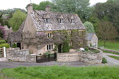
Davenport House, situated near St Peter's Church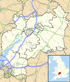
 Duntisbourne Abbots
Duntisbourne Abbots shown within GloucestershirePopulation 227 [1] OS grid reference SO970078 Parish Duntisbourne Abbots District Cotswold Shire county Gloucestershire Region South West Country England Sovereign state United Kingdom Post town CIRENCESTER Postcode district GL7 Dialling code 01285 Police Gloucestershire Fire Gloucestershire Ambulance Great Western EU Parliament South West England UK Parliament Cotswold List of places: UK • England • Gloucestershire Duntisbourne Abbots is a village and civil parish located in the English county of Gloucestershire. Duntisbourne Abbots forms part of the Cotswold District. It is home to the 'Five Mile House', a critically acclaimed eatery. It also features in the title of µ-Ziq's 2007 album; Duntisbourne Abbots Soulmate Devastation Technique.
St Peter's Church in the village was built in the 12th century, on the site of an earlier, Saxon, church. Its tower dates from Norman times, and has belfry lights of pierced stone lattice work that date from the 13th century. Inside the church, the font also dates from Norman times, while the unusual chancel arch dates from an extensive Victorian restoration.[2]
References
- ^ "Neighbourhood Statistics - Area: Duntisbourne Abbots CP (Parish)". http://www.neighbourhood.statistics.gov.uk/dissemination/LeadDatasetList.do?a=7&b=794766&c=Duntisbourne+Abbots&d=16&g=447853&i=1001x1003&m=0&r=1&s=1219996412363&enc=1&domainId=15. Retrieved 2008-08-29.
- ^ "Duntisbourne Abbots - St. Peter". Gloucestershire County Council. http://www.gloucestershire.gov.uk/index.cfm?articleid=1693. Retrieved 2008-08-29.
External links
 Media related to Duntisbourne Abbots at Wikimedia CommonsCategories:
- Villages in Gloucestershire
- Cotswold (district)
- Gloucestershire geography stubs


Wikimedia Foundation. 2010.