- Duntisbourne Leer
-
Coordinates: 51°45′58″N 2°02′13″W / 51.766°N 2.037°W
Duntisbourne Leer 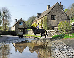
 Duntisbourne Leer
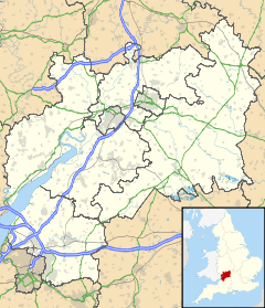
Duntisbourne Leer shown within GloucestershireOS grid reference SO975075 - London 84 mi (135 km) District Cotswold Shire county Gloucestershire Region South West Country England Sovereign state United Kingdom Post town CIRENCESTER Postcode district GL7 Dialling code 01285 Police Gloucestershire Fire Gloucestershire Ambulance Great Western EU Parliament South West England UK Parliament Cotswold List of places: UK • England • Gloucestershire Duntisbourne Leer is in the county of Gloucestershire, and lies within the Cotswolds, a range of hills designated an Area of Outstanding Natural Beauty. It is approximately 10.5 miles (16.9 km) southeast of Gloucester and approximately 4.5 miles (7.2 km) northwest of Cirencester. Nearby villages include Duntisbourne Abbots and Duntisbourne Rouse.
The village was recorded as Duntesborne: Lyre Abbey in the Domesday Book, the name coming from the Old English for "stream of a man called Dunt" and the fact the hamlet belonged to the Abbey of Lyre in Normandy.[1]
Reference
- ^ Mills, A. D. (1998). Dictionary of English Place-Names. Oxford University Press. pp. 120. ISBN 0192800744.
Categories:- Gloucestershire geography stubs
- Villages in Gloucestershire
- Cotswold (district)


Wikimedia Foundation. 2010.