- Winnigstedt
-
Winnigstedt 

 WinnigstedtLocation of Winnigstedt within Wolfenbüttel district
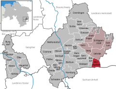

Coordinates 52°04′0″N 10°45′58″E / 52.066667°N 10.76611°ECoordinates: 52°04′0″N 10°45′58″E / 52.066667°N 10.76611°E Administration Country Germany State Lower Saxony District Wolfenbüttel Municipal assoc. Schöppenstedt subdivisions 2 districts Mayor Kurt Alpers (CDU) Basic statistics Area 12.05 km2 (4.65 sq mi) Elevation 91 m (299 ft) Population 766 (31 December 2010)[1] - Density 64 /km2 (165 /sq mi) Other information Time zone CET/CEST (UTC+1/+2) Licence plate WF Postal code 38170 Area code 05336 Website www.winnigstedt.de Winnigstedt is a municipality in the district of Wolfenbüttel, in Lower Saxony, Germany.
Border point Mattierzoll
The southern quarter of Mattierzoll has been a border area between different territories since centuries. After World War II, it bordered on the Soviet occupation zone, later the German Democratic Republic. In the 1950s, the border village on the western side became a railway junction. Here the railway Helmstedt-Holzminden was connected with the Braunschweig-Schöningen railway and the private railway Mattierzoll-Heudeber.
Towns and municipalities in Wolfenbüttel (district) Baddeckenstedt | Börßum | Burgdorf | Cramme | Cremlingen | Dahlum | Denkte | Dettum | Dorstadt | Elbe | Erkerode | Evessen | Flöthe | Gielde | Haverlah | Hedeper | Heere | Heiningen | Hornburg | Kissenbrück | Kneitlingen | Ohrum | Remlingen | Roklum | Schladen | Schöppenstedt | Sehlde | Semmenstedt | Sickte | Uehrde | Vahlberg | Veltheim | Werlaburgdorf | Winnigstedt | Wittmar | Wolfenbüttel
References
- ^ "Bevölkerungsfortschreibung" (in German). Landesbetrieb für Statistik und Kommunikationstechnologie Niedersachsen. 31 December 2009. http://www1.nls.niedersachsen.de/statistik/html/parametereingabe.asp?DT=K1000014&CM=Bev%F6lkerungsfortschreibung.
Categories:- Municipalities in Lower Saxony
- Wolfenbüttel (district)
- Braunschweig region geography stubs


Wikimedia Foundation. 2010.