- Jerécuaro
-
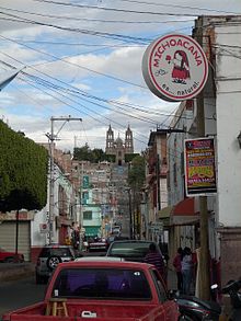 Jerécuaro city street scene in 2011, with the Guadalupe Sanctuary of El Calvario on the horizon.
Jerécuaro is a Mexican city (and municipality) located in the lowlands of the state of Guanajuato. The municipality has an area of 828.3 square kilometres (2.7% of the surface of the state) and is bordered to the north by Apaseo el Alto, to the east by Coroneo and the state of Querétaro, to the south by Tarandacuao, to the southwest with Acámbaro, and to the northwest with Tarimoro. The municipality had 55,311 inhabitants according to the 2005 census.[1][2]
The municipal president of Jerécuaro and its many smaller outlying communities is Dr. J. Carmen Mondragón Reséndiz.[3]
Official website
- Jerécuaro (in Spanish)
- JERECUARO.COM (in Spanish)
References
- ^ "2005 Census". INEGI: Instituto Nacional de Estadística, Geografía e Informática. http://www.inegi.gob.mx/est/contenidos/espanol/sistemas/conteo2005/localidad/iter/. Retrieved 2007-03-22.
- ^ Guanajuato "Mexican Municipality Encyclopedia". Enciclopedia de los Municipios de México. http://www.e-local.gob.mx/wb2/ELOCAL/EMM_guanajuato Guanajuato. Retrieved 2007-03-22.
- ^ Municipal president Detailed profile
Coordinates: 20°09′02″N 100°30′37″W / 20.1505555656°N 100.510277788°W
Guanajuato, Gto. (capital) Municipalities Abasolo · Acámbaro · San Miguel de Allende · Apaseo el Alto · Apaseo el Grande · Atarjea · Celaya · Manuel Doblado · Comonfort · Coroneo · Cortázar · Cuerámaro · Doctor Mora · Dolores Hidalgo · Guanajuato · Huanímaro · Irapuato · Jaral del Progreso · Jerécuaro · León · Moroleón · Ocampo · Pénjamo · Pueblo Nuevo · Purísima del Rincón · Romita · Salamanca · Salvatierra · San Diego de la Unión · San Felipe · San Francisco del Rincón · San José Iturbide · San Luis de la Paz · Santa Catarina · Santa Cruz de Juventino Rosas · Santiago Maravatío · Silao · Tarandacuao · Tarimoro · Tierra Blanca · Uriangato · Valle de Santiago · Victoria · Villagrán · Xichú · Yuriria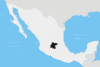 Categories:
- Municipalities of Guanajuato
- Populated places in Guanajuato


Wikimedia Foundation. 2010.