- Salvatierra, Guanajuato
Infobox City
official_name = San Andrés de Salvatierra
native_name = Ciudad de Salvatierra
nickname =
motto =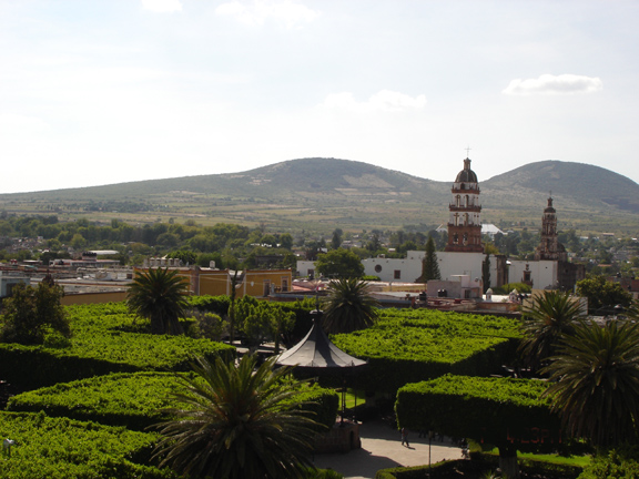
imagesize = 260px
image_caption = View of the Tetilla hills
image_shield =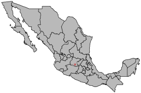
mapsize =
map_caption = Location of Salvatierra in Mexico
subdivision_type = Country
subdivision_type = Country
subdivision_name =
subdivision_type1 =
subdivision_name1 =
subdivision_type2 =
subdivision_name2 =
government_type =
leader_title = Municipal president
leader_name = Raúl Ulises Cardiel Gutiérrez (PAN)
leader_title1 =
leader_name1 =
leader_title2 =
leader_name2 =
leader_title3 =
leader_name3 =
established_title = Founded (officially)
established_date =1644 (By Garcia Sarmiento de Sotomayor)
established_title2 =
established_date2 =
established_title3 =
established_date3 =
area_magnitude =
unit_pref = Metric
area_footnotes =
area_total_km2 =
area_total_sq_mi =
area_land_km2 =
area_land_sq_mi =
area_water_km2 =
area_water_sq_mi =
area_water_percent =
area_urban_km2 =
area_urban_sq_mi =
area_metro_km2 =
area_metro_sq_mi =
population_as_of = 2000
population_note =
population_total = 34,066 city; 94,558 municipality
population_density_km2 =
population_density_sq_mi =
population_metro =
population_density_metro_km2 =
population_density_metro_sq_mi =
population_urban =
timezone = Central Standard Time
utc_offset = -6
timezone_DST = Central Daylight Time
utc_offset_DST = -5
latd = 20 | latm=12 | lats=56 | latNS=N
longd = 100 | longm=53 | longs=46 | longEW=W
elevation_m = 1700
elevation_ft =
postal_code_type =
postal_code = 38900
website = [http://salvatierra.guanajuato.gob.mx Official Website of the City of Salvatierra]
footnotes = Average temperature 18°CSalvatierra is a Mexican city (and municipality) located in the valley of Huatzindeo in the lowlands of the state of
Guanajuato . With an area of 507.70 square kilometres, Salvatierra accounts for 1.66% the total area of the state. It is bordered to the north byTarimoro and Cortazar, to the south byAcámbaro and the state ofMichoacán , to the west byYuriria andSantiago Maravatío , and to the northeast byJaral del Progreso . The municipality had a total of 94,558 inhabitants of which 34,066 lived in the city of Salvatierra, according to the 2005 census. [Cite web | url=http://www.inegi.gob.mx/est/contenidos/espanol/sistemas/conteo2005/localidad/iter/ | title=2005 Census | work=INEGI: Instituto Nacional de Estadística, Geografía e Informática | accessdate=2007-03-22] [Cite web | url=http://www.e-local.gob.mx/wb2/ELOCAL/EMM_guanajuato Guanajuato | title=Mexican Municipality Encyclopedia | work=Enciclopedia de los Municipios de México | accessdate=2007-03-22] .In
pre-Columbian times the area was known as Guatzindeo or "Place of beautiful vegetation" [ [http://www.guanajuato.gob.mx/ingles/archisalva.htm City profile] ] by the mostlyP'urhépecha inhabitants.an Andrés de Salvatierra
The city of San Andrés de Salvatierra was founded under the order of Spanish viceroy Don Garcia Sarmiento de Sotomayor, 2nd Count of Salvatierra and Marquis of Sobroso, on February 9th, 1644 [ [http://www.bisabuelos.com/lug/salvatierra.html Notas geográficas, históricas y geneológicas (in Spanish)] ] . In 1646 the town was granted the title of city, becoming the first city in the state of Guanajuato. [ [http://www.guanajuato.gob.mx/ingles/archisalva.htm Joya colonial del estado de Guanajuato] ]
Due to its rich soil and strategic location (midway between the three most populated areas, namely Mexico City, Guadalajara, and Monterrey) for most of the next three centuries the city was one of the most prosperous in the state of Guanajuato. However, unlike León, Irapuato, and Celaya, Salvatierra never developed into a strong industrial town and has seen its working population shrink with many choosing to relocate to nearby cities and others leaving the country entirely to seek jobs in the
United States . Some microregions in the minicipality have immigration levels of well over 50%, while the rate stands at 30% in the city. [ [http://migrantes.guanajuato.gob.mx/municipios/Cuestionarios%20de%20Municipios/Salvatierra.htm Programa de protección a migrantes] ]Cities and areas in the United States with sizable populations from Salvatierra include
Los Angeles, CA ,Dallas, TX ,Detroit, MI , theAtlanta metro area,Chicago , and especially Moline, inIllinois . [ [http://migrantes.guanajuato.gob.mx/municipios/cuestionarios_municipios05_06/Salvatierra.htm Firman Convenio de Hermandad] ]Microregions
ister cities
*flagicon|USA
Irwindale, CA
*flagicon|USAMoline, IL References
External links
* [http://cupareo.webcindario.com Cupareo, Mpio. de Salvatierra]
* [http://www.guanajuato.gob.mx/municipios/salvatierra.htm Municipality Web site] (in Spanish)
Wikimedia Foundation. 2010.