- Chickasaw Park
-
Chickasaw Park 
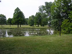
Chickasaw Park's fishing pondType Municipal park Location Louisville, Kentucky Coordinates 38°14′32″N 85°49′54″W / 38.2423°N 85.8317°WCoordinates: 38°14′32″N 85°49′54″W / 38.2423°N 85.8317°W Area 61 acres (250,000 m2) Created 1923 Operated by Metro Parks Chickasaw Park is a municipal park in Louisville, Kentucky's west end. It is fronted to the west by the Ohio River. It was formerly the country estate of political boss John Henry Whallen, and began development as a park in 1923, but was not completed until the 1930s. The original plan for Chickasaw Park was designed by the Frederick Law Olmsted firm.
It features the city's only free clay tennis courts. Other features include baseball, volleyball and basketball facilities, and a spray pool.
When the other Olmsted parks in Louisville were closed to Blacks in 1924, Chickasaw was the only one that remained open to them until the parks were desegregated in 1954 by Mayor Andrew Broaddus.
See also
External links
List of Parks in Louisville Metro Area Kentucky Parks Beargrass Creek · Belvedere · Bernheim Forest · Blackacre · Central Park · Cherokee Park · Chickasaw Park · Extreme Park · Fort Nelson Park · Joe Creason · Iroquois Park · Jefferson Memorial Forest · Seneca Park · Shawnee Park · Tom Sawyer State Park · Waterfront ParkIndiana Parks Charlestown State Park · Clark State Forest · Falls of the Ohio State Park · Lapping Park · Perrin Park · Sam Peden Community Park · Warder ParkCategories:- Parks in Louisville, Kentucky
- Louisville, Kentucky stubs
Wikimedia Foundation. 2010.
