- Melsbach
-
Melsbach 
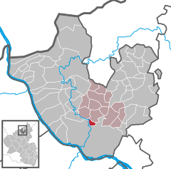
Coordinates 50°29′27″N 7°28′42″E / 50.49083°N 7.47833°ECoordinates: 50°29′27″N 7°28′42″E / 50.49083°N 7.47833°E Administration Country Germany State Rhineland-Palatinate District Neuwied Municipal assoc. Rengsdorf Mayor Joachim Herzog (SPD) Basic statistics Area 2.80 km2 (1.08 sq mi) Elevation 170 m (558 ft) Population 2,031 (31 December 2010)[1] - Density 725 /km2 (1,879 /sq mi) Other information Time zone CET/CEST (UTC+1/+2) Licence plate NR Postal code 56581 Area code 02634 Website www.gemeinde-melsbach.de Melsbach is a municipality in the district of Neuwied, in Rhineland-Palatinate, Germany.
Regional parts of Melsbach's surrounding belongs to the well-known air-spa of Rengsdorf.
Until the late 1960s in Melsbach a significant clay-mining was held. Today only a winding tower marks the place where the mines´ entrance has been.
Melsbach was a firm contract partner of the regionally famous pumice-mining corporation Kann-Werke until the late 1980s, when the pumice-fields ran out of containings.
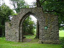
A tourist attraction and popular panorama-motive are the ruins of the Kreuzkirche (church of the cross), situated at the southern entrance of the village.
Contents
Village history
- 500 BC: a bronze bucket from this time is found in the local area
- 1267: first documentary mentioning of the village: Graf Gottfried von Eppstein, the Younger, sells his estate
- 1278: Melsbach becomes the parish of Rengsdorf
- 1357: Melsbach becomes an important customer's facility
- 1399: first description of the church-of-the-cross as a place of pilgrimage
- 1692/1720: Melsbach receives its own school
- 1747: Melsbach enparts to the parish of Altwied
- 1789: lignite- and clayfields are found
- 1786–1880: Digging of alaun in the first alaun-mine of Rhineland-Palatinate
- 1850: At the Laubach creek blue schist ist digged
- 1863: first kermis in Melsbach, first calling of the regional wine "Melsbacher Goldberg"
- 1865: year of the foundation of the Burschenverein Melsbach
- 1907: Foundation of the Auxiliary Fire Brigade
Sources
- Albert Hardt, Im Wiedischen Land, Rengsdorf 1989 – Geschichte der Orte in der Verbandsgemeinde Rengsdorf; therein: Melsbach und seine Geschichte, page 377 ff.
References
- ^ "Bevölkerung der Gemeinden am 31.12.2010" (in German). Statistisches Landesamt Rheinland-Pfalz. 31 December 2010. http://www.statistik.rlp.de/fileadmin/dokumente/berichte/A1033_201022_hj_G.pdf.
External links
Anhausen · Asbach · Bad Hönningen · Bonefeld · Breitscheid · Bruchhausen · Buchholz · Dattenberg · Datzeroth · Dernbach · Dierdorf · Döttesfeld · Dürrholz · Ehlscheid · Erpel · Großmaischeid · Hammerstein · Hanroth · Hardert · Harschbach · Hausen · Hümmerich · Isenburg · Kasbach-Ohlenberg · Kleinmaischeid · Kurtscheid · Leubsdorf · Leutesdorf · Linkenbach · Linz am Rhein · Marienhausen · Meinborn · Melsbach · Neustadt · Neuwied · Niederbreitbach · Niederhofen · Niederwambach · Oberdreis · Oberhonnefeld-Gierend · Oberraden · Ockenfels · Puderbach · Ratzert · Raubach · Rengsdorf · Rheinbreitbach · Rheinbrohl · Rodenbach bei Puderbach · Roßbach · Rüscheid · Sankt Katharinen · Stebach · Steimel · Straßenhaus · Thalhausen · Unkel · Urbach · Vettelschoß · Waldbreitbach · Windhagen · Woldert
Categories:- Municipalities in Rhineland-Palatinate
- Neuwied district geography stubs
Wikimedia Foundation. 2010.


