- Northeim
-
Northeim 

 NortheimLocation of the town of Northeim within Northeim district
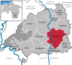

Coordinates 51°42′24″N 10°00′4″E / 51.70667°N 10.00111°ECoordinates: 51°42′24″N 10°00′4″E / 51.70667°N 10.00111°E Administration Country Germany State Lower Saxony District Northeim Town subdivisions 16 Ortsteile Mayor Harald Kühle (SPD) Basic statistics Area 145.67 km2 (56.24 sq mi) Elevation 120 m (394 ft) Population 29,431 (31 December 2010)[1] - Density 202 /km2 (523 /sq mi) Other information Time zone CET/CEST (UTC+1/+2) Licence plate NOM Postal code 37154 Area code 05551 Website www.northeim.de Northeim is a city in Lower Saxony, Germany, seat of the district of Northeim, with, as of 2002, a population of 31 000. It's located on the German Half-Timbered House Road.
Contents
History
Rittigau or County of Northeim
Rittigau or Grafschaft NortheimState of the Holy Roman Empire ← 
before 982 – 1147  →
→Capital Northeim Government Principality Historical era Middle Ages - First documentary
mention of city
800- First documentary
mention of Rittigau
982- First documentary
mention of city
as comital seat
1002- Stem duchy of Bavaria
in personal union
1061–70- Comital line extinct 1147 - Northeim gained
town rights
1252Today part of  Germany
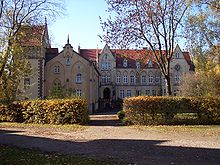 Castle of Imbshausen
Northeim is first mentioned in 800 in a document recording a property transfer by a Frankish nobleman to the Abbey of Fulda. In the 10th century the surrounding region became a county, administered by the Counts of Northeim. The first of them, Siegfried is mentioned in 982. From 1061 to 1070 Count Otto II held the stem duchy of Bavaria as an Imperial fief, but lost it again because of his involvement in the Saxon plot against King Henry IV.
The monastery of St. Blasius was founded around 1100. In 1252 Northeim obtained town rights, and from 1384 to 1554 it was a member of the Hanseatic League. The city became part of the Kingdom of Hanover.[when?]
Northeim is the subject of William Sheridan Allen's book The Nazi Seizure of Power (ISBN 0-531-05633-3), a comprehensive study of the success of Nazism at town level. The book describes how the Nazis took over all social groups in the city and Nazified them, but failed to instil positive enthusiasm for the Nazi state. Instead, the population was "atomized" and deprived of the means to express group grievances. The book has been criticized for neglecting the role of the churches, which remained largely autonomous. However, even its critics say that the book is crucial to our understanding of Nazi Germany and has played a key role in shaping scholarship.[2] Imbshausen, the site of a post-World War II British sector Displaced Persons camp, was incorporated into the city in 1974.[3]
In 15th November 1992 an express train crashed into the wreckage of a derailed freight train near Northeim. 11 people died and 52 were injured.
Cultural amenities
- The city has a city museum and archive.
- There is an outdoor stage outside the city.
- Some of the old city wall still stands, including a watch-tower.
Transportation
Hanoverian Southern Railway connects Northeim with cities like Göttingen and Hanover. Solling Railway connects Northeim with cities at the southern part of Solling-Vogler Nature Park.
Notable natives and residents
- Otto of Nordheim, Duke of Bavaria
- Heinrich Kreipe, World War II general who died there (1976)
See also
References
- ^ "Bevölkerungsfortschreibung" (in German). Landesbetrieb für Statistik und Kommunikationstechnologie Niedersachsen. 31 December 2009. http://www1.nls.niedersachsen.de/statistik/html/parametereingabe.asp?DT=K1000014&CM=Bev%F6lkerungsfortschreibung.
- ^ The Nazi Seizure of Power: The Experience of a Single German Town 1922–1945, Times Higher Education
- ^ Imbshausen on Heraldry of the World
External links
Bad Gandersheim | Bodenfelde | Dassel | Einbeck | Hardegsen | Kalefeld | Katlenburg-Lindau | Kreiensen | Moringen | Nörten-Hardenberg | Northeim | Uslar Categories:
- Towns in Lower Saxony
- Former principalities
- Former countries in Europe
- States of the Holy Roman Empire
- States and territories established in the 8th century
- States and territories disestablished in 1147
- Braunschweig region geography stubs


Wikimedia Foundation. 2010.