- Monzingen
-
Monzingen 
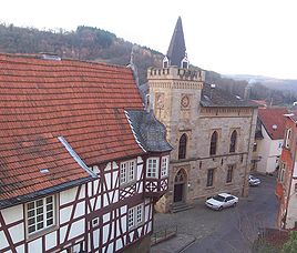
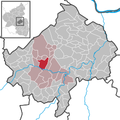
Coordinates 49.7993°N 7.5911°E / 49.7993°N 7.5911°ECoordinates: 49.7993°N 7.5911°E / 49.7993°N 7.5911°E Administration Country Germany State Rhineland-Palatinate District Bad Kreuznach Municipal assoc. Sobernheim Mayor Adolf Geib Basic statistics Area 12.18 km2 (4.70 sq mi) Elevation 180 m (591 ft) Population 1,660 (31 December 2010)[1] - Density 136 /km2 (353 /sq mi) Other information Time zone CET/CEST (UTC+1/+2) Licence plate KH Postal code 55569 Area code 06751 Website www.Monzingen.de Monzingen is a municipality in the district of Bad Kreuznach in Rhineland-Palatinate, in western Germany.
Founded over 1200 years ago the village contains a number of historic buildings (See German Wikipedia page).
References
- ^ "Bevölkerung der Gemeinden am 31.12.2010" (in German). Statistisches Landesamt Rheinland-Pfalz. 31 December 2010. http://www.statistik.rlp.de/fileadmin/dokumente/berichte/A1033_201022_hj_G.pdf.
Vogt, Werner (1991). Monzingen an der Nahe. Neusser Dr. und Verl., Neuss. ISBN 3880946825.
Categories:- Municipalities in Rhineland-Palatinate
- Bad Kreuznach district geography stubs
Wikimedia Foundation. 2010.


