- Ohio State Route 716
-
State Route 716
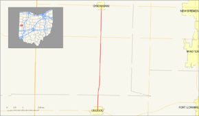
Route information Maintained by ODOT Length: 6.70 mi[2] (10.78 km) Existed: 1937[1] – present Major junctions South end:  SR 705 in Osgood
North end:  SR 274 in Chickasaw
Location Counties: Darke, Mercer Highway system Ohio highways
Interstates • U.S. Routes • State Routes←  SR 715
SR 718  →
→State Route 716 (SR 716, OH 716) is a state highway in the western part of the U.S. state of Ohio. Its southern terminus is at State Route 705 in the village of Osgood in northeastern Darke County. The northern terminus of State Route 716 is at State Route 274 in the village of Chickasaw in southeastern Mercer County. For its entire length, State Route 716 runs parallel to, and approximately 4 miles (6.4 km) to the east of, U.S. Route 127.
The highway was assigned in 1937 on a routing from State Route 705 in Osgood to an unnumbered highway in Franklin Township. The route was truncated to its current northern terminus in 1973. State Route 716 has remained intact ever since.
Contents
Route description
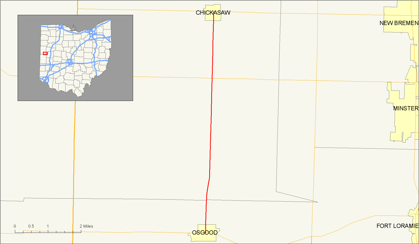
State Route 716 begins at an intersection with State Route 705 in the Darke County village of Osgood. The highway heads northward through downtown Osgood and then into the rural regions, which includes spontaneous residential homes and fields. Not far after Osgood, State Route 716 intersects with Township Road 7 (Darke-Mercer County Line Road), which as stated, runs along the county line. The highway crosses the line into Mercer County and continues northward through rural areas. There is an intersection with a local road, Indian Trail Road, soon after.[3]
State Route 716 remains mainly unchanged for a little while until it nears the Marion Township village of Maria Stein. It then passes Marion Local High School. In Maria Stein, it intersects with State Route 119. In Maria Stein, the highway is more urbanized, with more homes and commercial buildings surrounding the highway. However, this is only for a short time, as State Route 716 leaves Maria Stein after the intersection with State Route 119. The route continues northward for a short distance into Chickasaw, where it terminates at State Route 274.[3]
History
State Route 716 was established in 1937. Its original path consisted of its entire current routing, State Route 274 between Chickasaw and 1 mile (1.6 km) west of Chickasaw in Marion Township, and a currently unnumbered road from Marion Township to 1 mile (1.6 km) east of Montezuma in Franklin Township.[1][4]
In 1973, State Route 716 was scaled back on the north end to its current northern terminus at State Route 274 in Chickasaw. The road went westward at the intersection with State Route 274, and went on a short concurrency before turning off for the north. It continued to its then northern terminus. The former stretch of State Route 716 from Chickasaw to Marion Township was re-numbered as State Route 274, and the stretch from Marion Township to Franklin Township was decommissioned.[5][6]
Major intersections
County Location Mile[2] Destinations Notes Darke Osgood 0.00 SR 705Southern terminus. Mercer Marion Township 4.68  SR 119
Chickasaw 6.70 SR 274Northern terminus. 1.000 mi = 1.609 km; 1.000 km = 0.621 mi References
- ^ a b Ohio Department of Transportation (1937). Ohio State Map (Map).
- ^ a b Ohio Department of Transportation. "Technical Services Straight Line Diagrams". http://www.odotonline.org/techservapps/SLD/default.htm. Retrieved 2008-06-21.
- ^ a b Yahoo! Inc. Yahoo! Maps – overview map of State Route 716 (Map). Cartography by NAVTEQ. http://maps.yahoo.com/#mvt=h&lat=40.431696&lon=-84.486486&zoom=16&q1=40.339768%2C-84.495273&q2=40.436825%2C-84.493331. Retrieved 2008-06-25.
- ^ Ohio Department of Transportation (1936). Ohio State Map (Map).
- ^ Ohio Department of Transportation (1973). Ohio State Map (Map).
- ^ Ohio Department of Transportation (1972). Ohio State Map (Map).
Categories:- State highways in Ohio

Wikimedia Foundation. 2010.