- Tiefenthal
-
For Tiefenthal in the district of Bad Kreuznach, see Tiefenthal, Bad Kreuznach.
Tiefenthal 

 TiefenthalLocation of Tiefenthal within Bad Dürkheim district
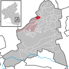

Coordinates 49°32′18″N 8°06′14″E / 49.53833°N 8.10389°ECoordinates: 49°32′18″N 8°06′14″E / 49.53833°N 8.10389°E Administration Country Germany State Rhineland-Palatinate District Bad Dürkheim Municipal assoc. Hettenleidelheim Mayor Edwin Gaub (CDU) Basic statistics Area 4.21 km2 (1.63 sq mi) Elevation 290 m (951 ft) Population 814 (31 December 2010)[1] - Density 193 /km2 (501 /sq mi) Other information Time zone CET/CEST (UTC+1/+2) Licence plate DÜW Postal code 67311 Area code 06351 Tiefenthal is an Ortsgemeinde – a municipality belonging to a Verbandsgemeinde, a kind of collective municipality – in the Bad Dürkheim district in Rhineland-Palatinate, Germany.
Contents
Geography
Location
The municipality lies in a small hollow with northern slopes between the Eisbach and Eckbach valleys in the Palatinate. Tiefenthal belongs to the Verbandsgemeinde of Hettenleidelheim, whose seat is in the like-named municipality. Until 1969, the municipality belonged to the now abolished district of Frankenthal.
History
In 1318, the municipality had its first documentary mention as Dyfendal.
Religion
In 2007, 45.4% of the inhabitants were Evangelical and 35.4% Catholic. The rest belonged to other faiths or adhered to none[2].
Politics
Municipal council
The council is made up of 12 council members, who were elected at the municipal election held on 7 June 2009, and the honorary mayor as chairman.
The municipal election held on 7 June 2009 yielded the following results[3]:
SPD CDU WGR Total 2009 3 5 4 12 seats 2004 2 5 5 12 seats Coat of arms
The German blazon reads: In Rot ein goldenes Tatzenkreuz.
The municipality’s arms might in English heraldic language be described thus: Gules a cross pattée humetty Or.
The arms were approved by the now defunct Regierungsbezirk administration in Neustadt and go back to a seal from 1724. They are borrowed from the arms once borne by the Counts of Leiningen-Westerburg, to whom Tiefenthal belonged[4].
Economy and infrastructure
Transport
A few kilometres away lies the Wattenheim interchange on the Autobahn A 6. Historically, a branch of the Eistalbahn (railway) once linked the municipality with Grünstadt.
Famous people
Sons and daughters of the town
- Wolfgang Wolf (1957– ), former football coach for 1. FC Kaiserslautern
- Arno Wolf (1959– ), former footballer with 1. FC Kaiserslautern
References
- ^ "Bevölkerung der Gemeinden am 31.12.2010" (in German). Statistisches Landesamt Rheinland-Pfalz. 31 December 2010. http://www.statistik.rlp.de/fileadmin/dokumente/berichte/A1033_201022_hj_G.pdf.
- ^ KommWis, Stand: 31.12.2007
- ^ Kommunalwahl Rheinland-Pfalz 2009, Gemeinderat [1]
- ^ Karl Heinz Debus: Das große Wappenbuch der Pfalz. Neustadt an der Weinstraße 1988, ISBN 3-9801574-2-3
- This article incorporates information from the German Wikipedia.
Altleiningen · Bad Dürkheim · Battenberg · Bissersheim · Bobenheim am Berg · Bockenheim an der Weinstraße · Carlsberg · Dackenheim · Deidesheim · Dirmstein · Ebertsheim · Ellerstadt · Elmstein · Erpolzheim · Esthal · Forst an der Weinstraße · Frankeneck · Freinsheim · Friedelsheim · Gerolsheim · Gönnheim · Großkarlbach · Grünstadt · Haßloch · Herxheim am Berg · Hettenleidelheim · Kallstadt · Kindenheim · Kirchheim an der Weinstraße · Kleinkarlbach · Lambrecht · Laumersheim · Lindenberg · Meckenheim · Mertesheim · Neidenfels · Neuleiningen · Niederkirchen bei Deidesheim · Obersülzen · Obrigheim · Quirnheim · Ruppertsberg · Tiefenthal · Wachenheim · Wattenheim · Weidenthal · Weisenheim am Berg · Weisenheim am Sand Categories:
- Municipalities in Rhineland-Palatinate
- Rheinhessen-Pfalz geography stubs


Wikimedia Foundation. 2010.