- Springville, Alabama
Infobox Settlement
official_name = Springville, Alabama
settlement_type =Town 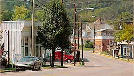
imagesize =
image_caption = Downtown Springville
image_
mapsize = 250px
map_caption = Location in St. Clair County and the state ofAlabama
mapsize1 =
map_caption1 =
subdivision_type = Country
subdivision_type1 = State
subdivision_type2 = County
subdivision_name =United States
subdivision_name1 =Alabama
subdivision_name2 = St. Clair
government_type =
leader_title =
leader_name =
established_date =
area_magnitude =
area_total_km2 = 16.6
area_total_sq_mi = 6.4
area_land_km2 = 16.6
area_land_sq_mi = 6.4
area_water_km2 = 0
area_water_sq_mi = 0
elevation_ft = 725
elevation_m = 221
population_as_of = 2000
population_footnotes =
population_total = 2521
population_metro =
population_density_km2 = 151.9
population_density_sq_mi = 393.9
timezone = Central (CST)
utc_offset = -6
latd = 33 |latm = 46 |lats = 8 |latNS = N
longd = 86 |longm = 28 |longs = 16 |longEW = W
timezone_DST = CDT
utc_offset_DST = -5
postal_code_type =ZIP code
postal_code = 35146
area_code = 205
blank_name = FIPS code
blank_info = 01-72600
blank1_name = GNIS feature ID
blank1_info = 0164863
footnotes =
website =Springville is a town in St. Clair County,
Alabama ,United States . At the 2000 census the population was 2,521.Geography
Springville is located at coor dms|33|46|8|N|86|28|16|W|city (33.768950, -86.471037)GR|1.
According to the
U.S. Census Bureau , the town has a total area of 6.4square mile s (16.6km² ), of which, 6.4 square miles (16.6 km²) of it is land and 0.04 square miles (0.1 km²) of it (0.31%) is water.Demographics
As of the
census GR|2 of 2000, there were 2,521 people, 990 households, and 767 families residing in the town. Thepopulation density was 393.8 people per square mile (152.1/km²). There were 1,049 housing units at an average density of 163.8/sq mi (63.3/km²). The racial makeup of the town was 90.56% White, 7.74% Black or African American, 0.16% Native American, 0.28% Asian, 0.16% Pacific Islander, and 1.11% from two or more races. 0.24% of the population were Hispanic or Latino of any race.There were 990 households out of which 34.4% had children under the age of 18 living with them, 62.8% were married couples living together, 11.5% had a female householder with no husband present, and 22.5% were non-families. 20.5% of all households were made up of individuals and 8.3% had someone living alone who was 65 years of age or older. The average household size was 2.55 and the average family size was 2.93.
In the town the population was spread out with 24.9% under the age of 18, 6.9% from 18 to 24, 30.1% from 25 to 44, 26.2% from 45 to 64, and 11.9% who were 65 years of age or older. The median age was 38 years. For every 100 females there were 97.4 males. For every 100 females age 18 and over, there were 88.5 males.
The median income for a household in the town was $43,397, and the median income for a family was $53,859. Males had a median income of $35,977 versus $25,542 for females. The
per capita income for the town was $20,518. About 8.0% of families and 10.8% of the population were below thepoverty line , including 11.1% of those under age 18 and 23.4% of those age 65 or over.Movies
Although a small Alabama town, Springville has been the site of filming for two movies:
*1987 - a gangster film called the "Verne Miller Story " (released on video entitled "Gangland") starringScott Glenn .
*2001 - "Rustin " (starringMeat Loaf andZachary Ty Bryan ).While neither of these films did very well in the Box Office or the eyes of critics and moviegoers, you can see a lot of what Springville,Alabama looks like in the latter of the two.References
External links
* [http://www.stclaircountyal.com/springville/springville.htm Springville, AL Home Page]
* [http://www.homesteadhollow.com/ Homestead Hollow festival]
Wikimedia Foundation. 2010.