2007 Guatemala earthquake
- 2007 Guatemala earthquake
earthquake
title=2007 Guatemala earthquake
date= June 13 2007
magnitude = 6.7 Mw
depth=convert|23|km|mi|0
location=coord|13.623|S|90.797|W
countries affected = GUA
tsunami = none
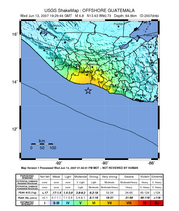
casualties = 0|The 2007 Guatemala earthquake occurred on June 13, 2007 occurred at 19:29:46 UTC (13:29:46 local time). The epicenter was located in the Pacific Ocean, south of Puerto Quetzal, about 115 km (70 miles) south-southwest of Guatemala City.[cite web | url=http://earthquake.usgs.gov/eqcenter/eqinthenews/2007/us2007dnbi/#details | publisher= | title=Historic Eartquakes - Magnitude 6.7 OFFSHORE GUATEMALA| author=USGS | access | format=] ]
The quake was reportedly felt in Guatemala, El Salvador and parts of Mexico. There were no reports of major damages or casualties.[ ]
While the USGS assigned a magnitude of 6.7 for this event,[ many local seismological agencies in Guatemala, El Salvador and Nicaragua only registered the quake in the 5.5 - 6.0 range.Fact|date=July 2008 These calculations are more accurate due to the seismographs' locations closer to the epicenter, and are in agreement with the minor shaking reported by residents.Fact|date=July 2008]
In addition, the USGS coins all movements as earthquakes, while in Latin America, small movements such as this one are called tremors. This misnomer confused the international community into thinking this event was much larger and more severe than it really was.Fact|date=January 2008
ee also
*Earthquakes in Guatemala
References
Wikimedia Foundation.
2010.
Look at other dictionaries:
2007 Kent earthquake — US Geological Survey map showing the position of the earthquake Date 28 April 2007 (2007 04 28) Magnitude 4.3 ML … Wikipedia
2007 Peru earthquake — Earthquake title=2007 Peru earthquake date= August 15 2007 Map of the Peru coastline, showing location and strength of quake. Star marks epicenter. magnitude = 8.0 Mw depth=39 kilometres (24.2 mi) location=coord|13.32|S|76.51|W|display=inline,titl… … Wikipedia
2007 Noto earthquake — Coordinates: 37°16′N 136°36′E / 37.267°N 136.6°E / 37.267; 136.6 … Wikipedia
Guatemala City — Guatemala La Nueva Guatemala de la Asunción City Guatemala City Starting at the … Wikipedia
Guatemala — Infobox Country native name = República de Guatemala conventional long name = Republic of Guatemala common name = Guatemala national motto = Libre Crezca Fecundo Grow Free and Fertile national anthem = Himno Nacional de Guatemala official… … Wikipedia
2007 Chūetsu offshore earthquake — Coordinates: 37°57′N 138°44′E / 37.95°N 138.733°E / 37.95; 138.733 … Wikipedia
Earthquake — For other uses, see Earthquake (disambiguation). Global earthquake epicenters, 1963–1998 … Wikipedia
2007 Alum Rock earthquake — Date October 30, 2007 (2007 10 30) Magnitude 5.6 Mw … Wikipedia
Guatemala — Guatemalan, adj., n. /gwah teuh mah leuh/; Sp. /gwah te mah lah/, n. 1. a republic in N Central America. 11,558,407; 42,042 sq. mi. (108,889 sq. km). 2. Also called Guatemala City. a city in and the capital of this republic. 917,322. * * *… … Universalium
Guatemala 2007 earthquake — On June 13th 2007, there was a 6.8 magnitude earthquake in Guatemala. According to the U.S. Geological Survey, the earthquake struck approximately 115 km (70 miles) south southwest of Guatemala City. The USGS estimates the depth at 64.8 km (40.3… … Wikipedia