- Ashland, Alabama
Infobox Settlement
official_name = Ashland, Alabama
settlement_type =Town 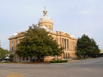
imagesize =
image_caption = Clay County Courthouse, Ashland, AL
image_

mapsize = 250px
map_caption = Location in Clay County and the state ofAlabama
mapsize1 =
map_caption1 =
subdivision_type = Country
subdivision_type1 = State
subdivision_type2 = County
subdivision_name =United States
subdivision_name1 =Alabama
subdivision_name2 = Clay
government_type =
leader_title =
leader_name =
established_date =
area_magnitude =
area_total_km2 = 18.8
area_total_sq_mi = 7.2
area_land_km2 = 18.7
area_land_sq_mi = 7.2
area_water_km2 = 0.1
area_water_sq_mi = 0
elevation_ft = 1119
elevation_m = 341
population_as_of =2007
population_footnotes = cite web|url=http://www.census.gov/popest/cities/tables/SUB-EST2007-04-01.csv|title=Annual Estimates of the Population for Incorporated Places in Alabama|publisher=United States Census Bureau |date=2008-07-10|accessdate=2008-07-14]
population_total =1873
population_metro =
population_density_km2 = 104.5
population_density_sq_mi = 272.9
timezone = Central (CST)
utc_offset = -6
latd = 33 |latm = 16 |lats = 19 |latNS = N
longd = 85 |longm = 50 |longs = 12 |longEW = W
timezone_DST = CDT
utc_offset_DST = -5
postal_code_type =ZIP code
postal_code = 36251
area_code = 256
blank_name = FIPS code
blank_info = 01-02860
blank1_name = GNIS feature ID
blank1_info = 0159091
footnotes =
website =Ashland is a town [ [http://www.census.gov/popest/geographic/boundary_changes/index.html US Census change list] ] in Clay County,
Alabama ,United States . The population was 1,965 at the 2000 census, at which time it was a city; according to 2005 Census Bureau estimates, the population was 1,885. [http://www.census.gov/popest/cities/files/SUB-EST2005-all.csv] The town is thecounty seat of Clay County.History
Ashland draws its name from the plantation home of
Henry Clay , a nineteenth-century American statesman and orator who represented Kentucky in both the House of Representatives and Senate. Fifteen Clay counties in the United States are named for "The Great Compromiser," known for his ability to bring others to agreement during a most contentious era of American politics.The century-old county courthouse on the town square entered the National Register of Historic Places on November 11, 1976. Visit Archiplanet to learn more about the structure. [http://www.archiplanet.org/wiki/Clay_County_Courthouse%2C_Ashland%2C_Alabama]
Geography
Ashland is located at coor dms|33|16|20|N|85|50|13|W|city (33.272206, -85.836925)GR|1.
According to the
U.S. Census Bureau , the city had a total area of 7.3square mile s (18.8km² ), of which, 7.2 square miles (18.7 km²) of it is land and 0.04 square miles (0.1 km²) of it (0.41%) is water.At 1130 feet, Ashland is Alabama's highest elevated county seatGR|3.
Demographics
As of the
census GR|2 of 2000, there were 1,965 people, 854 households, and 519 families residing in the city. Thepopulation density was 271.5 people per square mile (104.8/km²). There were 975 housing units at an average density of 134.7/sq mi (52.0/km²). The racial makeup of the city was 73.74% White, 25.29% Black or African American, 0.10% Asian, 0.20% from other races, and 0.66% from two or more races. 2.70% of the population were Hispanic or Latino of any race.There were 854 households out of which 27.5% had children under the age of 18 living with them, 43.0% were married couples living together, 15.0% had a female householder with no husband present, and 39.2% were non-families. 37.5% of all households were made up of individuals and 20.0% had someone living alone who was 65 years of age or older. The average household size was 2.14 and the average family size was 2.80.
In the city the population was spread out with 21.1% under the age of 18, 8.0% from 18 to 24, 25.9% from 25 to 44, 22.2% from 45 to 64, and 22.8% who were 65 years of age or older. The median age was 41 years. For every 100 females there were 82.3 males. For every 100 females age 18 and over, there were 76.9 males.
The median income for a household in the city was $23,469, and the median income for a family was $33,583. Males had a median income of $24,715 versus $18,500 for females. The
per capita income for the city was $13,927. About 12.2% of families and 19.9% of the population were below thepoverty line , including 27.2% of those under age 18 and 23.4% of those age 65 or over.Notable natives
*
Hugo Black , born in Harlan in Clay County, served as an associate justice of the United States Supreme Court from 1937 until 1971. His first law office was on the square in Ashland.
*Jerry Weems - The winningest basketball coach in Ashland's history.
*Bob Riley , Alabama's 52nd governor, is a native of Ashland.Education
Public schools are: *Source: Alabama Board of Education School Report Card for 2005-2006
*According to theAlabama High School Athletic Association CCHS holds seven Class 2A championships. *Football 1994, 1995, 1996, 2000, 2005
*Boys basketball 1991, 1992
*And, 1-A State Football Champions in 2002Interesting facts
* The 2003 movie "
Big Fish " (based on a book by Daniel Wallace of the same title) features the character Edward Bloom, who grew up in Ashland.References
External links
Wikimedia Foundation. 2010.