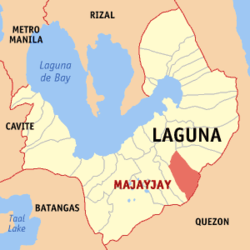
- Majayjay, Laguna
-
Municipality of Majayjay
Bayan ng Majayjay— Municipality — 
SealMap of Laguna showing the location of Majayjay Location in the Philippines Coordinates: 14°09′N 121°28′E / 14.15°N 121.467°ECoordinates: 14°09′N 121°28′E / 14.15°N 121.467°E Country  Philippines
Region CALABARZON (Region IV-A) Province Laguna District 4th District of Laguna Founded 1571 Barangays 40 Government - Mayor Teofilo C. Guerra Area - Total 69.58 km2 (26.9 sq mi) Population (2007) - Total 23,681 - Density 340.3/km2 (881.5/sq mi) Time zone PST (UTC+8) ZIP code 4005 Income class 4th Population Census of Majayjay Census Pop. Rate 1995 18,989 — 2000 22,159 3.37% 2007 23,681 0.92% Majayjay is a 4th class municipality in the province of Laguna, Philippines. It is located at the foot of Mt. Banahaw, and stands 1,000 feet above sea level. One hundred twenty kilometers south of Manila, it is bounded by the municipality of Magdalena on the north, by Lucban in Quezon province on the south, by Luisiana on the east, and by Liliw on the west. According to the latest census, it has a population of 23,681 people in 4,978 households.
Contents
Barangays
Majayjay is politically subdivided into 40 barangays.
- Amonoy
- Bakia
- Balanak
- Balayong
- Banilad
- Banti
- Bitaoy
- Botocan
- Bukal
- Burgos
- Burol
- Coralao
- Gagalot
- Ibabang Banga
- Ibabang Bayucain
- Ilayang Banga
- Ilayang Bayucain
- Isabang
- Malinao
- May-It
- Munting Kawayan
- Olla
- Oobi
- Origuel (Pob.)
- Panalaban
- Pangil
- Panglan
- Piit
- Pook
- Rizal
- San Francisco (Pob.)
- San Isidro
- San Miguel (Pob.)
- San Roque
- Santa Catalina (Pob.)
- Suba
- Talortor
- Tanawan
- Taytay
- Villa Nogales
History
Majayjay was founded in the year 1571 and its name was derived from the word "Ma" which means many. Some say that in the old days, to reach this town of hilly terrain, one had to pant, saying "hay, hay" (which means "sigh") and later the name became Majayjay.
Taytay Falls
If Cavinti, Laguna has the Pagsanjan Falls, Majayjay has the Taytay Falls. Others call it the Majayjay Falls or even Imelda Falls, because ex-First Lady Imelda Marcos financed the promotion of tourism in this place. It is a two-storey high falls located in a remote scenery where the forestry is abundant. To reach Taytay Falls, one has to go down the stone steps leading to a kilometer-long trail. Constructed in 2008, during the past, reaching Taytay Falls is a very hard task, as there were no marked trails during that time. Recently, the World Bank has sponsored the promotion of tourism in Taytay Falls.
External links
- Philippine Standard Geographic Code
- 1995 Philippine Census Information
- 2000 Philippine Census Information
- 2007 Philippine Census Information
- 2007 Philippine Census Information
Gov. Emilio Ramon EjercitoMunicipalities Component Cities Biñan • Calamba • San Pablo • Santa RosaCategories:- Philippines geography stubs
- Municipalities of Laguna (province)
Wikimedia Foundation. 2010.


