- Church Fenton
-
Coordinates: 53°49′30″N 1°13′16″W / 53.825101°N 1.221023°W
Church Fenton 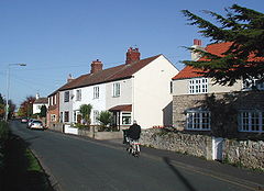
Nanny Lane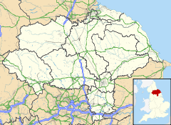
 Church Fenton
Church Fenton shown within North YorkshirePopulation 789 (2001) OS grid reference SE513368 Parish Church Fenton District Selby Shire county North Yorkshire Region Yorkshire and the Humber Country England Sovereign state United Kingdom Post town TADCASTER Postcode district LS24 Dialling code 01937 Police North Yorkshire Fire North Yorkshire Ambulance Yorkshire EU Parliament Yorkshire and the Humber UK Parliament Selby and Ainsty List of places: UK • England • Yorkshire Church Fenton is a village and civil parish in the Selby district of North Yorkshire, England. The village is home to many commuters and is served by a railway station; Church Fenton railway station. Neighbouring villages include Cawood and Ulleskelf. It is about 6 miles (9.7 km) from Tadcaster and 3 miles (4.8 km) from Sherburn-in-Elmet. RAF Church Fenton is located immediately north east of the village.[1]
The name 'Church Fenton' means a village with a church in fen or marshland.[2] The village was recorded along with nearby Little Fenton as Fentun in the Domesday Book.
There is a village website[3] which has a well written history along with details of local groups and events.
The village is also home to a Met Office Weather station[4]
References
- ^ Royal Air Force Church Fenton
- ^ List of generic forms in place names in the United Kingdom and Ireland
- ^ Church Fenton Community Web Site
- ^ Met Office Church Fenton
External links
 Media related to Church Fenton at Wikimedia Commons
This Selby location article is a stub. You can help Wikipedia by expanding it.

