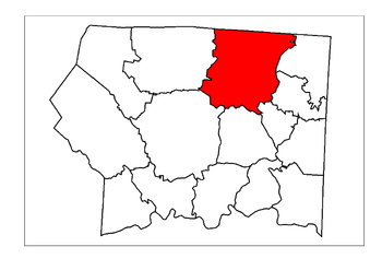
- Mount Airy Township, Surry County, North Carolina
-
Mount Airy Township is one of fifteen townships in Surry County, North Carolina. The township had a population of 24,828 according to the 2000 census.
Geographically, Mount Airy Township occupies 43.1 square miles (112 km2) in northern Surry County, with its northern border being with the state of Virginia. Mount Airy Township is the most populated township of Surry County, accounting for nearly 35% of the total county population. The only incorporated municipality within Mount Airy Township is the City of Mount Airy. Additionally, there are several smaller, unincorporated communities located here, including, Bannertown, Boones Hill, Flat Rock, Franklin, Salem, Sheltontown, Slate Mountain, Toast, White Plains, and White Sulphur Springs.
Municipalities and communities of Surry County, North Carolina County seat: Dobson City Towns Dobson | Elkin‡ | Pilot Mountain
Townships CDPs Unincorporated
communitiesAlbion | Ararat | Ash Hill | Bannertown | Blackwater | Blevins Store | Boones Hill | Bottom | Burch | Cedar Hill | Combstown | Copeland | Crooked Oak | Crutchfield | Devotion | Fairview | Franklin | Hills Grove | Indian Grove | Jenkinstown | Ladonia | Level Cross | Little Richmond | Long Hill | Lowgap | Mount Herman | Mountain Park | Mulberry | New Hope | Oak Grove | Pine Hill | Pine Ridge | Poplar Springs | Red Brush | Rockford | Round Peak | Salem | Salem Fork | Sheltontown | Shoals | Siloam | Slate Mountain | State Road | Stony Knoll | Thurmond | Turkey Ford | Union Cross | Union Hill | Westfield | White Sulphur Springs | Woodville | Zephyr
Footnotes ‡This populated place also has portions in an adjacent county or counties
Coordinates: 36°31′09″N 80°36′38″W / 36.5192688°N 80.610489°W
Categories:- Townships in Surry County, North Carolina
- North Carolina geography stubs
Wikimedia Foundation. 2010.


