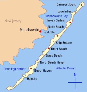
Manahawkin Bay Bridge — Map of New Jersey Route 72 showing the bridge crossing Manahawkin Bay The Dorland J. Henderson Memorial Bridge,[1] familiarly known as the Manahawkin Bay Bridge or (while technically inaccurate) The Causeway, is a steel girder bridge that spans… … Wikipedia
Manahawkin, New Jersey — CDP Map of … Wikipedia
Manahawkin Baptist Church — U.S. National Register of Historic Places … Wikipedia
Barnegat Bay — Looking north northwest from Barnegat Light toward mainland New Jersey Barnegat Bay is a small brackish arm of the Atlantic Ocean, approximately 30 miles (50 km) long, along the coast of Ocean County, New Jersey in the United States. It is a … Wikipedia
Great Bay (New Jersey) — Great Bay is located in southern New Jersey s Atlantic Coastal Plain in Ocean and Atlantic Counties, about ten miles (13 km) north of Atlantic City and 87 mi (140 km) south of New York City. The Mullica River flows into the bay, and together they … Wikipedia
New Jersey Route 72 — Route 72 Barnegat Road R … Wikipedia
Stafford Township, New Jersey — Township Map of Stafford Township in Ocean County. Inset; Location of Ocean County highlighted in the State of New Jersey … Wikipedia
Ship Bottom, New Jersey — Infobox Settlement official name = Ship Bottom, New Jersey settlement type = Borough nickname = motto = imagesize = image caption = image mapsize = 250x200px map caption = Map of Ship Bottom in Ocean County. Inset: Location of Ocean County… … Wikipedia
Thomas A. Mathis and J. Stanley Tunney Bridges — Thomas A. Mathis Bridge J. Stanley Tunney Bridge Official name Thomas A. Mathis Bridge (eastbound) J. Stanley Tunney Bridge (westbound) Carries 6 lanes of Route 37 Crosses Barnegat Bay with crossing through Pelican Island Locale … Wikipedia
Fatigue (material) — Metal fatigue redirects here. For the video game, see Metal Fatigue (disambiguation). v · d · e Materials failure modes … Wikipedia

