Ongpangkong

Ongpangkong
Ongpangkong
—  village  —
Ongpangkong
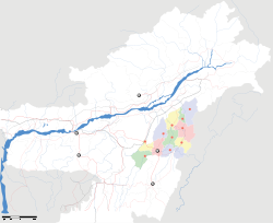
Location of Ongpangkong
in Nagaland and India
Coordinates 26°18′40″N 94°33′18″E / 26.311°N 94.5550°E / 26.311; 94.5550Coordinates: 26°18′40″N 94°33′18″E / 26.311°N 94.5550°E / 26.311; 94.5550
Country India
State Nagaland
District(s) Mokokchung
Time zone IST (UTC+05:30)
Area

• Coastline


0 kilometres (0 mi)

Ongpangkong are the largest range in Mokokchung District in India. The district headquarter Mokokchung is itself located in this range. Important villages are Longsa, Ungma, Chungtia, Longkum, Mokokchung Village, Khensa, Aliba, Mangmetong Mekuli, Kinunger, etc.


Wikimedia Foundation. 2010.

Игры ⚽ Поможем сделать НИР

Look at other dictionaries:

  • Yimyu — is one of the 15 wards that make up Mokokchung town in India. It is an extensive area and forms the northwestern part of Mokokchung. Until 2003, Yimyu was a separate town and not under Mokokchung Municipal Council. However the last two decades… …   Wikipedia

  • Mokokchung district — This article is about the district. For its eponymous headquarters, see Mokokchung. Mokokchung district   District   …   Wikipedia

  • Mokokchung — This article is about the municipality in Nagaland, India. For its namesake district, see Mokokchung district. Mokokchung   city   …   Wikipedia

  • Ao Baptist Arogo Mungdang — Ao Baptist Arogo Mungdang(ABAM) ( Ao Baptist Churches Convention ) is the largest Baptist convention affiliated to the Nagaland Baptist Council Churches, with over 125 full fledged churches, 25 fellowships, and average weekly church attendance… …   Wikipedia

  • Ao (Volk) — Die Ao sind ein Stamm der Naga im indischen Bundesstaat Nagaland. Sprache und Wohngebiet Bei der Volkszählung 2001 bestand er aus 232.000 Personen. Sie sprechen die nach ihnen benannte Sprache Ao.[1] Das kulturelle Zentrum der Ao ist die Stadt… …   Deutsch Wikipedia

Share the article and excerpts

Direct link
Do a right-click on the link above
and select “Copy Link”