- Robertsdale, Alabama
Infobox Settlement
official_name = Robertsdale, Alabama
settlement_type =City
nickname = The Hub of Baldwin County
motto =
imagesize =
image_caption =
image_
mapsize = 250px
map_caption =
mapsize1 =
map_caption1 =
subdivision_type = Country
subdivision_type1 = State
subdivision_type2 = County
subdivision_name =United States
subdivision_name1 =Alabama
subdivision_name2 = Baldwin
government_type =
leader_title =Mayor
leader_name = Charles H. Murphy
established_title = Incorporated
established_date = 1921
area_magnitude =
area_total_sq_mi = 5.5
area_total_km2 = 14.1
area_land_sq_mi = 5.5
area_land_km2 = 14.1
area_water_sq_mi = 0
area_water_km2 = 0
area_urban_sq_mi =
area_urban_km2 =
area_metro_sq_mi =
area_metro_km2 =
elevation_m = 45
elevation_ft = 148
latd = 30 |latm = 33 |lats = 16 |latNS = N
longd = 87 |longm = 42 |longs = 20 |longEW = W
population_as_of = 2000
population_note =
population_total = 3782
population_metro =
population_urban =
population_density_km2 = 267.4
population_density_sq_mi = 692.6
timezone = CST
utc_offset = -6
timezone_DST = CDT
utc_offset_DST = -5
website = http://www.robertsdale.org
postal_code_type =ZIP code s
postal_code = 36567, 36574
area_code = 251
blank_name = FIPS code
blank_info = 01-65208
blank1_name = GNIS feature ID
blank1_info = 0125703
footnotes =Robertsdale is a city in Baldwin County,
Alabama ,United States . At the 2000 census the population was 3,782.History
The Southern Plantation Corporation of Chicago, Illinois founded Robertsdale in 1905. The city's present location was chosen largely due to the fertile farmland and the fact that the Louisville and Nashville Railroad line had just recently made extensions to Foley, Alabama. The town was named after one of the officials of the Corporation, Dr. B.F. Roberts, and was incorporated in 1921.Fact|date=October 2007
Geography
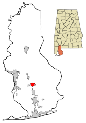
Robertsdale is located at 30°33'16.034" North, 87°42'20.038" West (30.554454, -87.705566)GR|1.
According to the
U.S. Census Bureau , the city has a total area of 5.5square mile s (14.1km² ), all of it land.Demographics
As of the
census GR|2 of 2000, there were 3,782 people, 1,444 households, and 1,054 families residing in the city. Thepopulation density was 692.6 people per square mile (267.4/km²). There were 1,573 housing units at an average density of 288.1/sq mi (111.2/km²). The racial makeup of the city was 94.26% White, 3.31% Black or African American, 0.71% Native American, 0.24% Asian, 0.42% from other races, and 1.06% from two or more races. 1.93% of the population were Hispanic or Latino of any race.There were 1,444 households out of which 36.4% had children under the age of 18 living with them, 55.3% were married couples living together, 13.7% had a female householder with no husband present, and 27.0% were non-families. 23.5% of all households were made up of individuals and 11.2% had someone living alone who was 65 years of age or older. The average household size was 2.60 and the average family size was 3.06.
In the city the population was spread out with 28.1% under the age of 18, 9.6% from 18 to 24, 27.7% from 25 to 44, 21.1% from 45 to 64, and 13.5% who were 65 years of age or older. The median age was 34 years. For every 100 females there were 90.3 males. For every 100 females age 18 and over, there were 86.9 males.
The median income for a household in the city was $33,194, and the median income for a family was $39,138. Males had a median income of $30,788 versus $19,852 for females. The
per capita income for the city was $16,510. About 9.8% of families and 11.2% of the population were below thepoverty line , including 12.0% of those under age 18 and 14.4% of those age 65 or over.Education
Robertsdale is a part of the
Baldwin County Public Schools system.Three elementary schools, a middle school, and a high school serve Robertsdale. A magnet high school is also located in Robertsdale.
Local Schools
Public
* Robertsdale High School (9-12)
* South Baldwin Center for Technology (11-12)
* Central Baldwin Middle School (7-8)
* Elsanor Elementary School (K-6)
* Robertsdale Elementary School (K-6)
* Rosinton Elementary School (K-6)Private
* Central Christian School (K-12)
* Faith Presbyterian Christian School (K-12)
* St. Patrick Catholic School (K4-8)References
External links
* [http://www.robertsdale.org City of Robertsdale Official Website]

Wikimedia Foundation. 2010.