- North Brother Island
-
North Brother Island is an island in the East River situated between the Bronx and Riker's Island. Its companion, South Brother Island, is a short distance away. Together, the two Brother Islands, North and South, have a land area of 20.12 acres (81,400 m2).
Contents
History
The island was uninhabited until 1885, when Riverside Hospital moved there from Blackwell's Island (now known as Roosevelt Island). Riverside Hospital was founded in the 1850s as the Smallpox Hospital to treat and isolate victims of that disease. Its mission eventually expanded to other quarantinable diseases.
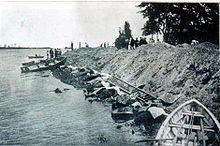
The island was the site of the wreck of the General Slocum, a steamship which burned on June 15, 1904. Over 1,000 people died either from the fire on board the ship or from drowning before the ship was beached on the island's shores.[1]
Typhoid Mary was confined to the island for over two decades until she died there in 1938.[2][3] The hospital closed shortly thereafter.
After World War II, the island housed war veterans who were students at local colleges, along with their families. After the nationwide housing shortage abated, the island was once again abandoned.
In the 1950s a center opened to treat adolescent drug addicts. The facility claimed to be the first to offer treatment, rehabilitation, and education facilities to young drug offenders. Heroin addicts were confined to this island and locked in a room until they were clean. Many of them believed they were being held against their will (as one person wrote on the wall). By the early 1960s widespread staff corruption and patient recidivism forced the facility to close.
The island is currently abandoned and off-limits to the public. Most of the original hospitals' buildings still stand, but are heavily deteriorated and in danger of collapse. A dense forest conceals the ruined hospital buildings and supports one of the area's largest nesting colonies of Black-crowned Night Heron.
Legacy
North Brother Island was featured in episode 8 ("Armed and Defenseless") of Life After People on the History Channel. It was used as an example of what would happen to structures after 45 years without humans.[4]
See also
References
- ^ "The General Slocum An Unlucky Craft. Has Had Collisions And Accidents By The Score. Has Run Ashore Many Times. She Was a Crack Harbor Boat Thirteen Years Ago. Capt. Van Schaick's Good Record". New York Times. June 16, 1904. http://query.nytimes.com/gst/abstract.html?res=9D04EFDE113DE633A25755C1A9609C946597D6CF. Retrieved 2010-02-28. "The General Slocum was one of the best known vessels about New York Harbor. Since the time of her launching, in 1891, she has been employed in so many different capacities, and on so many different runs, that possibly five out of every ten people in New York City have at some time been aboard of her, or have seen her at close range."
- ^ "'Typhoid Mary' Dies Of A Stroke At 68. Carrier of Disease, Blamed for 51 Cases and 3 Deaths, but She Was Held Immune". New York Times. November 12, 1938. http://select.nytimes.com/gst/abstract.html?res=F10D15FE3859117389DDAB0994D9415B888FF1D3. Retrieved 2010-02-28. "Mary Mallon, the first carrier of typhoid bacilli identified in America and consequently known as Typhoid Mary, died yesterday in Riverside Hospital on North Brother Island."
- ^ Williams, Timothy (November 20, 2007). "City Claims Final Private Island in East River". New York Times. http://www.nytimes.com/2007/11/20/nyregion/20brother.html?ex=1353214800&en=73c01f66adc6cd44&ei=5124&partner=permalink&exprod=permalink. Retrieved 2008-05-26. "The island — the smaller sibling of the better known North Brother Island, which is 500 feet to the north and once the quarantine home of Typhoid Mary ... Neighboring islands, including North Brother, became sites for hospitals that treated infectious diseases like typhus and tuberculosis and for mental hospitals, power plants, jails, homeless shelters and cemeteries for the indigent."
- ^ "Armed and Defenseless". History Channel. http://www.history.com/content/life_after_people/episode-guide/armed-and-defenseless. Retrieved 2010-02-28.
Further reading
- Seitz, Sharon & Miller, Stuart. (2003) The Other Islands of New York. ISBN 0-88150-502-1.
- North Brother and South Brother Islands: Block 9000, Block Group 9, Census Tract 5, Bronx County, New York United States Census Bureau
External links
- A historical article about the island accompanied by 60 recent photographs
- Brothers: NYC's worst maritime tragedy
- Photos of the islands in 2004, and images of the General Slocum from Forgotten New York.
- NYC Audubon Harbor Herons Project
- Harbor Herons Nesting Survey -recent reports on wading bird and gull nesting activity at North Brother Island
- Photos of the abandoned hospital Photographs and history of the abandoned Riverside Hospital
- A second gallery of images taken by urban explorers
- New York Times Lens Blog - The Places We Don't See
Coordinates: 40°48′02″N 73°53′55″W / 40.800613°N 73.898699°W
Islands of New York City Barren Island · The Blauzes · Broad Channel Island · Chimney Sweeps · City Island · Coney Island · Ellis Island · Governors Island · Hart Island · High Island · Hoffman Island · Hunter Island · Isle of Meadows · Liberty Island · Long Island · Manhattan · Mill Rock · North Brother Island · Prall's Island · Randall's Island · Rat Island · Rikers Island · Roosevelt Island · Ruffle Bar · Shooters Island · South Brother Island · Staten Island · Swinburne Island · Travers Island · Twin Island · U Thant Island · Wards Island
 Categories:
- Islands of New York City
- History of New York City
- PS General Slocum
- East River

Wikimedia Foundation. 2010.