Orava (reservoir)

Orava (reservoir)
Orava
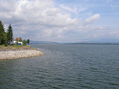
Coordinates 49°23′59″N 19°32′44″E / 49.39972°N 19.54556°E / 49.39972; 19.54556Coordinates: 49°23′59″N 19°32′44″E / 49.39972°N 19.54556°E / 49.39972; 19.54556
Lake type reservoir
Primary outflows Orava river
Basin countries Slovakia
Surface area 35.2 km²

Orava is a reservoir in northernmost Slovakia, which is the largest lake in Slovakia (35.2 km²). It has been constructed between 1941 and 1953 as a dam built on the former two sources of the Orava river. Several former villages had to be inundated for this purpose. Probably the best known of them was Slanica, the birthplace of the Slovak intellectual and cleric Anton Bernolák (Antonius Bernolacius). Today, the reservoir is protected by the Horná Orava Protected Landscape Area.


Wikimedia Foundation. 2010.

Игры ⚽ Поможем сделать НИР

Look at other dictionaries:

  • Orava — may refer to: Orava (region), a region in Slovakia and Poland Orava (river) in Slovakia Orava (castle), a castle in Slovakia Orava (reservoir), a reservoir in Slovakia Comitatus (Kingdom of Hungary), a historic administrative county of the… …   Wikipedia

  • Orava River — Geobox River name = Orava map size = map caption = other name = hu. Árva other name1 = langWithName|de|German|Arwa other name2 = pl. Orawa country = Slovakia country1 = region = region1 = city = city1 = length = 60.9 length imperial = watershed …   Wikipedia

  • Orava (river) — Coordinates: 49°09′N 19°09′E / 49.15°N 19.15°E / 49.15; 19.15 …   Wikipedia

  • Orava (rivière) — Pour les articles homonymes, voir Orava. Orava (rivière) L Orava à Dolný Kubín Caractéristiques …   Wikipédia en Français

  • Námestovo — Coordinates: 49°24′10″N 19°28′53″E / 49.40278°N 19.48139°E / 49.40278; 19.48139 …   Wikipedia

  • List of dams and reservoirs — The following is a list of reservoirs and dams, arranged by continent and country. Contents 1 Africa 1.1 Botswana 1.2 Cameroon …   Wikipedia

  • List of reservoirs and dams — The List of reservoirs and dams is a link page for any reservoir or dam in the world, by continent.AfricaCameroon*Edea Dam *Song Loulou Dam *Lagdo DamNigeria*Kainji Dam *Jebba Dam *Shiroro Dam *Kano Dam *Kafin Zaki DamEgypt*Aswan Dams and Lake… …   Wikipedia

  • Geography of Slovakia — Slovakia is a landlocked Central European country with mountainous regions in the north and flat terrain in the south.AreaSlovakia lies between 49°36 48 and 47°44 21 northern latitude and 16°50 56 and 22°33 53 eastern longitude. The northernmost… …   Wikipedia

  • Kysuce — is a traditional informal name of a region in north western Slovakia, situated around the Kysuca river and bordering the Orava region in the east and the Czech Republic in the west. It consists of two districts, Čadca and Kysucké Nové Mesto. The… …   Wikipedia

  • Géographie de la Slovaquie — Continent Europe Région Europe centrale Coordonnées 48°40 N, 19°30 E Superficie …   Wikipédia en Français

Share the article and excerpts

Direct link
Do a right-click on the link above
and select “Copy Link”