- Dunstanburgh Castle
-
Dunstanburgh Castle Northumberland 
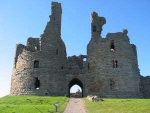
Entrance of Dunstanburgh Castle from the north-westCoordinates grid reference NU258220 Current
conditionRuins Current
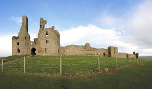
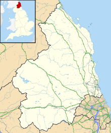
ownerEnglish Heritage, National Trust Dunstanburgh Castle lies on a spectacular headland on the coast of Northumberland in northern England, between the villages of Craster and Embleton.
The castle is the largest in Northumberland[1] and the site shows traces of much earlier occupation before the erection of the castle was started in 1313 by the Earl of Lancaster.[2]
Contents
History
Recent evidence suggests that the site of the castle was occupied in prehistoric times: however, the principal remains date from the 14th century.[3] In 1313, Earl Thomas of Lancaster, cousin of Edward II of England began construction of a massive fortress. By the time of his execution in 1322, the castle was substantially complete. John of Gaunt improved the castle in the late 14th century as the Duke of Lancaster.
The castle did not play a significant part in the border warfare against Scotland. In the Wars of the Roses the castle was held for the Lancastrians in 1462 and 1464. The damage done was not made good and the castle fell steadily into decay. A report in 1538 mentioned it as being a "very reuynus howsse and of smalle strength" and another source in 1550 described it as in "wonderfull great decaye". It continued to deteriorate and was robbed of stone for the building of other places in the area. The last private owner Sir Arthur Sutherland donated the castle to the Ministry of Works in 1929. The castle is now owned by the National Trust and in the care of English Heritage. It is a Scheduled Ancient Monument and a Grade I listed building. It lies within the Northumberland Coast Area of Outstanding Natural Beauty.
Turner painted Dunstanburgh many times, usually rising at dawn to do so. One of his oil paintings of the subject is in the Dunedin Public Art Gallery. Another is in the National Gallery of Victoria.
Description
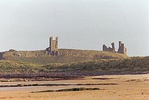
The castle occupies a prominent headland about 1 mile (1.6 km) north of Craster. On the south side there is a gentle slope towards the castle. The northerly approach is much steeper and the northern perimeter juts into Embleton Bay forming a 150-foot (46 m) cliff. The headland itself is part of the Great Whin Sill, a geological formation stretching across Northumberland.
There are signs of medieval rig-and-furrow on the slopes near to the castle - possible evidence of subsistence farming for the castle inhabitants.
The present castle encloses the entire 11 acres (4.5 ha) headland. The southern approach is protected by a long enceinte wall punctuated by two rectangular towers (the Constable and Egyncleugh towers), two turrets and a large twin-towered gatehouse at the western corner. From the gatehouse, the wall carries northward along the hilltop to a rectangular turreted watch tower, known as the Lilburn Tower.
The twin-towered gatehouse served as the principal residential block of the castle. Under John of Gaunt, the gateway was blocked, and the entrance to the castle carried around to the left via a mantlet wall and tower, rendering the gatehouse a more secure traditional keep. The area at the rear of the twin-towered gatehouse was enclosed in a courtyard by walls and a tower to form an inner ward, with access on the east side.
Composed of two tall D-shaped towers, the gatehouse-keep is a masterpiece of 14th century castle design. Each tower was of four stories, and was originally capped by four turrets about 80 feet (24 m) above ground level. The long gate passage was protected by gates at each end and two soldiers' barracks line the passage at ground level. On the first floor the gatehouse was divided into three rooms, with the central one controlling the portcullis mechanism. On the second floor above ground level there was a large room running across the entire width of the gatehouse, comprising a hall and chambers. The arrangements of the other stories and above have not survived.
The castle had a very high standard of masonry, comfort and design, and was likely intended to house Earl Thomas and his entire retinue. Well-lit residential chambers furnished with fireplaces may be found in the Lilburn and Constable towers as well as in the gatehouse. The large, apparently unused land in the middle of the castle may have served as a billeting area for troops.
Recent evidence suggests that there may have been an additional defensive enceinte of the castle, enclosing the low flat land around the foot of the main fort. Evidence has been found of a wall originating on the north near the Lilburn tower and extending around, anticlockwise, to the coastline on the east, where there may have been a medieval port.
References
- ^ Linda Jonas and Laurie Jonas, The Heritage Trail, Heritage Trail Publications Limited, UK (1998)
- ^ Lumina Technologies, Reconstructive History of Dunstanburgh Castle, Northumberland, England, Santa Rosa, Ca. July 7, 2006
- ^ Prudames, David. [1] Archaeologists unlock hidden past of Dunstanburgh], 17 March 2004, Culture24. Accessed 26 November 2009.
- Images of Dunstanburgh Castle
- [dead link] English Heritage's 2003 excavations of the site
- English Heritage (1993). Dunstanburgh Castle - Guide. London: English Heritage. pp. 36 pp. ISBN 1 85074 350 9.
- (Albion Press, 2002) Glen Lyndon Dodds, Historic Sites of Northumberland & Newcastle upon Tyne, pp 79–84
External links
 Media related to Dunstanburgh Castle at Wikimedia Commons
- Visit Northumberland - The Official Visitor Site for Northumberland from Northumberland Tourism
- Dunstanburgh Castle information at the National Trust
- Dunstanburgh Castle information at English Heritage
- Information for teachers: English Heritage
- Risk assessment information for teachers: English Heritage
- CastleXplorer Dunstanburgh page
- Find public transport to Dunstanburgh Castle - buses stop about 45 minutes walk from the castle
County Durham Northumberland Alnwick · Aydon · Bamburgh · Belford · Bellingham · Bellister · Belsay · Berwick · Blenkinsop · Bothal · Bywell · Callaly · Cartington · Chillingham · Chipchase · Cotherstone · Coupland · Creswell · Dally · Dilston · Dunstanburgh · Elsdon · Etal · Featherstone · Ford · Haggerston · Halton · Haltwhistle · Harbottle · Haughton · Langley · Lindisfarne · Mitford · Morpeth · Norham · Ponteland · Prudhoe · Rothley · Tarset · Thirlwall · Twizell · Wark (on Tweed) · Wark (on Tyne) · Warkworth · WiddringtonTyne and Wear English Heritage properties in North East England County Durham Northumberland Aydon Castle · Belsay Hall, Castle & Gardens · Berwick-upon-Tweed Barracks & Main Guard · Berwick-upon-Tweed Castle & Ramparts · Black Middens Bastle House · Brinkburn Priory · Dunstanburgh Castle · Edlingham Castle · Etal Castle · Lindisfarne Priory · Norham Castle · Prudhoe Castle · Warkworth Castle & HermitageTyne and Wear Tees Valley Categories:- Castles in Northumberland
- English Heritage sites in Northumberland
- National Trust properties in Northumberland
- Visitor attractions in Northumberland
- Grade I listed castles
- Grade I listed buildings in Northumberland
- Scheduled Ancient Monuments in Northumberland
- Ruins in Northumberland
Wikimedia Foundation. 2010.


