- Oberdrauburg
-
Oberdrauburg 
 Oberdrauburg
Country Austria State Carinthia District Spittal an der Drau Mayor Hubert Schnedl (SPÖ) Area 69.91 km2 (27 sq mi) Elevation 632 m (2074 ft) Population 1,268 (1 January 2011)[1] - Density 18 /km² (47 /sq mi) Time zone CET/CEST (UTC+1/+2) Postal code 9781 Area code 04710 Website www.oberdrauburg.at Coordinates: 46°44′0″N 12°58′0″E / 46.733333°N 12.966667°E
Oberdrauburg is a market town in the district of Spittal an der Drau at the western rim of the Austrian state of Carinthia. It is situated near the Kärntner Tor (Carinthian Gate), where the Drava river crosses the border from East Tyrol to Carinthia. In the west it shares border with the Tyrolian municipality of Nikolsdorf. The name of the town corresponds with the municipality of Dravograd in Slovenia, former Unterdrauburg, where the Drava crosses the border from Carinthia to Lower Styria. The market town of Oberdrauburg also includes the Katastralgemeinden of Flaschberg and Zwickenberg.
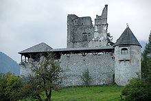 Hohenburg Castle
Transportation
Oberdrauburg is situated on the Drautal-Straße highway (Bundesstraße B 100) running from Spittal an der Drau to Lienz. Here the Plöckenpass-Straße B 110 highway branches off, leading to the Gailbergsattel mountain pass and Kötschach-Mauthen. Rail transport is available at the Oberdrauburg Station of the Drautalbahn (Drava Valley Railway) line.
Twin towns
 Türkenfeld, Germany since 1990
 Signa, Italy since 1996
References
Bad Kleinkirchheim · Baldramsdorf · Berg im Drautal · Dellach im Drautal · Flattach · Gmünd · Greifenburg · Großkirchheim · Heiligenblut · Irschen · Kleblach-Lind · Krems · Lendorf · Lurnfeld · Mallnitz · Malta · Millstatt · Mörtschach · Mühldorf · Oberdrauburg · Obervellach · Radenthein · Rangersdorf · Reißeck · Rennweg am Katschberg · Sachsenburg · Seeboden · Spittal an der Drau · Stall · Steinfeld · Trebesing · Weissensee · Winklern
 Categories:
- Cities and towns in Carinthia
- Austria–Slovenia border crossings
- Carinthia geography stubs


Wikimedia Foundation. 2010.