- Old Turn Junction
-
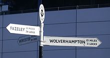
 Fingerpost at Old Turn Junction.
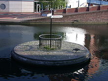
Old Turn Junction is a canal junction in Birmingham, England, where the Birmingham and Fazeley Canal meets the Birmingham Canal Navigations Main Line Canal. The junction features a circular island, installed during World War II, to allow the use of temporary dams to protect the railway tunnel beneath it, should the canal be breached by bombing.[1] The north tunnel of the Stour Valley railway line (main western approach to New Street Station) runs a few yards north east of the junction, under the Birmingham and Fazeley Canal.
The fingerpost at the junction was added on May 21, 1983, the first of many canal junctions to be signposted under John Phillips' leadership of the BCN Society.[2]
Contents
Nearby
Once at the heart of an industrial area, the junction is now overlooked wholly by recent developments, including the National Indoor Arena and the National Sea Life Centre, the latter being part of Brindleyplace. To the South-East is the International Convention Centre and Gas Street Basin, where the BCN ends and the Worcester and Birmingham Canal begins.
Other names
The original name for the junction was Deep Cutting Junction. Deep Cutting was the name of the short stretch of canal between the junction and Broad Street Tunnel.
When the Newhall Branch was closed in the early 20th century the name of the junction at Farmer's Bridge top lock (the original start of the Birmingham and Fazeley Canal) was transferred to the current Old Turn Junction, so Farmer's Bridge Junction was synonymous with Old Turn Junction and Deep Cutting Junction. In 1993, the name Farmer's Bridge Junction was dropped, leaving it again as Old Turn Junction.
See also
References
- ^ Birmingham's Canals, Ray Shill, 1999, 2002, ISBN 0-7509-2077-7
- ^ Phil Clayton. "Junctions of the BCN". Birmingham Canal Navigations Society. http://www.bcn-society.co.uk/bp176_junctions.php. Retrieved 2008-05-20.
- Perrott, David; Mosse, Jonathan (2006). Nicholson Waterways Guide 3 - Birmingham & the Heart of England. Collins. ISBN 978-0-00-721111-1.
- Shill, Ray. A Gas Street Trail. Heartlands Press. ISBN 0-9517755-3-7.
Coordinates: 52°28′45″N 1°54′50″W / 52.4792°N 1.9139°W
Categories:- Canal junctions in England
- Buildings and structures in Birmingham, West Midlands
- Transport in Birmingham, West Midlands
- Birmingham Canal Navigations
- West Midlands (county) geography stubs
Wikimedia Foundation. 2010.

