Chadiza

Chadiza
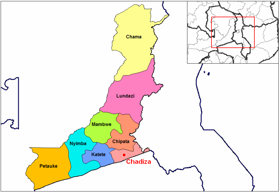
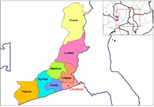
Location of Chadiza town and district in Eastern Province, Zambia

Chadiza is a town in the Eastern Province of Zambia, and is headquarters of Chadiza District. It lies 35 km south of the Great East Road and about 80 km south-south-west of Chipata on a plateau (elevation 1050 m) studded by isolated rocky hills, between the middle Luangwa valley and the Zambezi.


References

  • Terracarta/International Travel Maps, Vancouver Canada: "Zambia, 2nd edition", 2000

Coordinates: 14°04′S 32°26′E / 14.067°S 32.433°E / -14.067; 32.433


Wikimedia Foundation. 2010.

Игры ⚽ Нужен реферат?

Look at other dictionaries:

  • Chadiza — Geographische Lage von Chadiza Chadiza ist ein ländlicher Ort im Norden der Ostprovinz in Sambia, 40 Kilometer östlich von Katete und 50 Kilometer südlich von Chipata. Chadiza liegt 908 Meter über dem Meeresspiegel und ist Sitz der Verwaltung des …   Deutsch Wikipedia

  • Chadiza — Localización de Chadiza en Zambia. Chadiza es una localidad de Zambia, capital del distrito homónimo. Se encuentra en la Provincia del Este, cerca de Malaui, 35 kilómetros al sur de la Gran Carretera del Este y a unos 80 al suroeste de la capital …   Wikipedia Español

  • Chadiza — Original name in latin Chadiza Name in other language Chadiza State code ZM Continent/City Africa/Lusaka longitude 14.06779 latitude 32.43917 altitude 1066 Population 3690 Date 2012 01 17 …   Cities with a population over 1000 database

  • Chadiza District —   District   District location in Zambia Country …   Wikipedia

  • Chadiza District — Admin ASC 2 Code Orig. name Chadiza District Country and Admin Code ZM.03.921026 ZM …   World countries Adminstrative division ASC I-II

  • District de Chadiza — Districts de Zambie Vue sur une carte de District de Chadiza Administration Pays …   Wikipédia en Français

  • Ostprovinz (Sambia) — Lage der Ostprovinz in Sambia Die Ostprovinz (englisch Eastern Province) der Republik Sambia ist eine der neun Provinzen des Landes. Die Hauptstadt der Ostprovinz ist Chipata. Innerhalb der Provinz liegt der Südluangwa Nationalpark. In der… …   Deutsch Wikipedia

  • Districts of Zambia — Zambia This article is part of the series: Politics and government of Zambia President Michael Sata …   Wikipedia

  • Katete — Geographische Lage von Katete in Sambia Katete ist ein Ort mit 12.500 Einwohnern (Schätzung 2006) an der Great East Road in der Ostprovinz in Sambia. Er liegt 1.276 Meter über dem Meeresspiegel und ist Sitz der Verwaltung des gleichnamigen… …   Deutsch Wikipedia

  • List of cities and towns in Zambia — Map of Zambia This is a list of cities, towns, villages and missions in Zambia. Contents 1 Cities …   Wikipedia

Share the article and excerpts

Direct link
Do a right-click on the link above
and select “Copy Link”