Breitenbush River

Breitenbush River

Geobox River
name =Breitenbush River
native_name =
other_name =
other_name1 =


image_size =
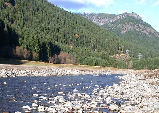
image_caption = Breitenbush River north of Detroit.
country = United States
country1 =
state = Oregon
state1 =
region = Mount Jefferson Wilderness
region1 =
district =
district1 =
city =
city1 =
length = 32
watershed =
discharge_location =
discharge =
discharge_max =
discharge_min =
discharge1_location =
discharge1 =
source_name = North Santiam River
source_location =
source_district = Marion County
source_region = Mount Jefferson Wilderness
source_state = Oregon
source_country = United States
source_lat_d =
source_lat_m =
source_lat_s =
source_lat_NS =
source_long_d =
source_long_m =
source_long_s =
source_long_EW =
source_elevation =
source_length =
mouth_name =
mouth_location =
mouth_district =
mouth_region =
mouth_state =
mouth_country =
mouth_lat_d =
mouth_lat_m =
mouth_lat_s =
mouth_lat_NS =
mouth_long_d =
mouth_long_m =
mouth_long_s =
mouth_long_EW =
mouth_elevation =
tributary_left =
tributary_left1 =
tributary_right =
tributary_right1 =
free_name =
free_value =


map_size =
map_caption =

The Breitenbush River is a tributary of the North Santiam River, approximately 20 mi (32 km) long, in western Oregon in the United States. It drains a rugged, forested area of the Cascade Range east of Salem.

It descends from several short forks in the Mount Jefferson Wilderness in the high Cascades of eastern Marion County. The South Fork Breitenbush River begins at creeks flowing from Bays Lake and Russell Lake within Jefferson Park at approximately elevation 6000 ft (1830 m) and flows WNW, joining with a number of other forks, variously unnamed depending on the map, or sometimes called North Fork of the South Fork of the South Fork, etc. The North Fork Breitenbush River begins at Breitenbush Lake (mostly on the Warm Springs Reservation) and joins with another fork which passes by Pyramid Lake. It flows WNW and connects with a half dozen other forks and creeks then turns WSW abeam Bald Butte. Several more creeks and Mink Creek and Rapidam Creek join before another fork

The North and South forks flow west, joining near the small community of Breitenbush. The combined stream flows generally WSW through the Willamette National Forest. It joins the North Santiam at Detroit. The lower 2 miles (3.2 km) of the river cut what is now an arm of Detroit Lake, formed by the Detroit Dam on the North Santiam. During the winter draw down of the reservoir, the original bed of the river is visible in its natural course.

ee also

* Breitenbush Hot Springs


Wikimedia Foundation. 2010.

Игры ⚽ Нужно сделать НИР?

Look at other dictionaries:

  • North Fork Breitenbush River — Location Marion County, Oregon Mouth elevation 694 metres (2,277 ft) The North Fork Breitenbush River is a river in the U.S. state of Oregon.[1] See also List of …   Wikipedia

  • Breitenbush Hot Springs — Retreat and Conference Center (pronunciation: BRIGHT en BUSH), commonly called Breitenbush Hot Springs or simply Breitenbush (or even The Bush by locals), is a worker owned resort community featuring holistic and spiritual retreats. It is… …   Wikipedia

  • Breitenbush — can refer to: * Breitenbush River, a tributary of the Santiam River in the U.S. state of Oregon * Breitenbush, Oregon, a community located on the Breitenbush River * Breitenbush Hot Springs, a retreat and conference center located on the… …   Wikipedia

  • Breitenbush, Oregon — Breitenbush is an unincorporated community in Marion County, Oregon, United States. The community is best known as the location of Breitenbush Hot Springs, a worker owned retreat and conference center.Breitenbush was named after the Breitenbush… …   Wikipedia

  • List of tributaries of the Columbia River — Tributaries and sub tributaries are hierarchically listed in order from the mouth of the Columbia River upstream. Major dams and reservoir lakes are also noted.Minor tributaries* Skipanon River (Oregon) * Lewis and Clark River (Oregon) * Youngs… …   Wikipedia

  • List of rivers of Oregon — This is a partial listing of rivers in the state of Oregon, United States of America. The list of Oregon rivers is organized alphabetically and by tributary structure. The list may also include streams known as creeks, brooks, forks, branches and …   Wikipedia

  • West Cascades Scenic Byway — The West Cascades Scenic Byway is a 220 mi (352 km) National Scenic Byway in the U.S. state of Oregon. The route is designed to provide a tour on the west side of the Cascade Range along the east side of the Willamette Valley.The route is roughly …   Wikipedia

  • National Register of Historic Places listings in Marion County, Oregon — Location of Marion County in Oregon The following list presents the full set of National Register of Historic Places listings in Marion County, Oregon, and offers brief descriptive information about each of them. The National Register of Historic …   Wikipedia

  • Marion County, Oregon — For counties with a similar name, see Marion County (disambiguation). Marion County, Oregon Location in the state of Oregon …   Wikipedia

  • Mary Barnard — Mary Ethel Barnard (December 6, 1909 – August 25, 2001) was an American poet, biographer and Greek to English translator. She is known for her clear interpretation of the works of Sappho, a translation which has never gone out of print. Paideuma …   Wikipedia

Share the article and excerpts

Direct link
Do a right-click on the link above
and select “Copy Link”