- Cloughton railway station
-
Cloughton 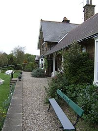
The former station at Cloughton Location Place Cloughton Area Scarborough Coordinates 54°19′57″N 0°26′45″W / 54.332500°N 0.445850°WCoordinates: 54°19′57″N 0°26′45″W / 54.332500°N 0.445850°W Grid reference TA011941 Operations Original company Scarborough & Whitby Railway Pre-grouping North Eastern Railway Platforms 2 History 1885 Opened 1965 Closed Disused railway stations in the United Kingdom Closed railway stations in Britain
A B C D–F G H–J K–L M–O P–R S T–V W–ZCloughton railway station was a railway station on the old Scarborough & Whitby Railway. It opened on 16 July 1885, and served the North Yorkshire village of Cloughton, and to a lesser extent the village of Burniston. It closed on 8 March 1965.
The station had a canopied goods shed, and in the '1956 Handbook of Stations', listed it as being able to handle general goods, livestock, horse boxes and prize cattle vans. it also had a 1 ton 10 cwt permanent crane.
The station has been restored and is currently (as of 2011[update]) a tea-room, with guest accommodation provided in a converted railway carriage, a converted goods shed, and two B&B suites.
References
- Butt, R.V.J. (1995). The Directory Of Railway Stations. Patrick Stephens Limited. ISBN 1-85260-508-1.
References
- Chapman, Stephen (2008). York to Scarborough Whitby & Ryedale. Bellcode Books. ISBN 9871871233 19 3.
External links
Preceding station Disused railways Following station Scalby Scarborough & Whitby Railway Hayburn Wyke Categories:- Disused railway stations in North Yorkshire
- Beeching closures in England
- Railway stations opened in 1885
- Railway stations closed in 1965
- Yorkshire and the Humber railway station stubs

Wikimedia Foundation. 2010.