- Southwest Cay
-
Southwest Cay Invasion Date 1975 Location Southwest Cay Result Vietnamese Capture of Southwest Cay Belligerents  Philippines
 South Vietnam
 North Vietnam later as Vietnam (unified)
Part of a series on the Spratly Islands 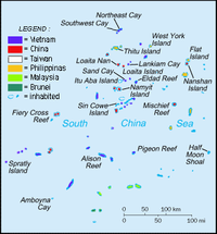
Spratly Islands
Spratly Islands dispute
Philippines and the Spratly Islands
Republic of Morac-Songhrati-Meads
Territorial disputes in the South China SeaConfrontations Islands by occupation Occupied by China (PRC)Occupied by MalaysiaOccupied by the PhilippinesOccupied by Taiwan (ROC)Occupied by Vietnam- Spratly Island · Truong Sa Island
- Southwest Cay · Song Tu Tay Island
- Sincowe Island · Sinh Ton Island
- Sandcay · Son Ca Island
- Namyit Island · Nam Yet Island
- Amboyna Cay · An Bang Island
Southwest Cay or Song Tu Tay Island (Tagalog: Pugad; Chinese: 南子岛; pinyin: Nanzi Dao; Vietnamese: Đảo Song Tử Tây) is an islet in the Spratly Islands. With an area of 12 hectares, it is the sixth largest Spratly island and the second largest among the Vietnamese-occupied Spratly islands. It holds the archipelago's highest point, at 4 meters above sea level. It is about 1.75 miles from Northeast Cay (Song Tu Dong Island) and is part of North Danger Reef. The island is claimed also by People's Republic of China, Republic of China (Taiwan) and the Philippines.
Southwest Cay was once a breeding place for birds and was covered with trees and guano. Export of guano was once carried out "on a considerable scale."[1]
Contents
History
In 1933, the French Government took official possession of the Spratley islands including North East Cay and South West Cay. Three ships, the Alerte, the Astrobale and the De Lanessan took part in the expedition. The following quotations are from an account given by H. Cucherousset in L'Eveil economique de l'Indochine (No. 790 of May 28, 1933):
”Further north still, at the level of Nhatrang, is the atoll named "North Danger" , the Alerte took possession of two sandy islands (cayes) where it found some Japanese fishing. The De Lanessan went there too and explored the little island. The latter is perceptibly higher than the others, the highest point reaching 5 metres. The phosphate beds are considerable and were much exploited by the Japanese. "
After possession had been taken, the French Ministry of Foreign Affairs published the following notice in the French Journal Officiel dated July 26, 1933 (page 7837):
"Notice concerning the occupation of certain islands by French naval units.
The French government has caused the under mentioned isles and islets to be occupied by French naval units:
- Group of two islands situated at latitude 111o29' north and longitude 114o21' east of Greenwich, with their dependent isles (36) (Possession taken April 10, 1933).
The above-mentioned isles and islets henceforward come under French sovereignty (this notice cancels the previous notice inserted in the Official Journal dated July 25, 1933, page 7784)."
In 1939, Japan occupied the islands and would remain there until the end of World War II. In 1956, France transferred the islands to South Vietnam.
In 1959, the South Vietnamese Government renamed the Song Tử islands (meaning twins after their resemblance to each other) "Tây" (meaning West) and "Đông" (meaning East) respectively. They was annexed to Phuoc Tuy province, South Vietnam. In 1961, the two South Vietnam Navy cruisers, the Van Kiep and the Van Don, landed on the islands of Song Tu Tay (South-West Cay).
On May 24, 1963, the sovereignty steles were rebuilt on Song Tu Dong (North East Cay) and Song Tu Tay (South West Cay) by crew members of the three vessels Huong Giang, Chi Lang and Ky Hoa of South Vietnam.
In 1968, Philippines troops occupied Song Tu Dong (North East Cay, Parola) and Song Tu Tay (Pugad).
After PRC had occupied the Paracels islands, Republic of Vietnam troops in February 1974 occupied Song Tu Tay Island as part of Operation Tran Hung Dao 48.
Captured by Vietnam
In 1975, a party was held for the Philippine commanding officer at Parola. Philippine forces guarding Pugad Island attended the party and upon their return, found that the South Vietnamese, who were then Allies, had occupied the island in their absence.
In April, 1975, there was a skirmish between South Vietnam troop and North Vietnam task force on this island. The North Vietnam task force won and has occupied the island ever since. Some of the South Vietnamese who had taken over the island from the Philippines fled Pugad Island and swam to Parola island to seek refuge.
Although the PRC, ROC (Taiwan) and Philippines all claim Parola, no clashed have been recorded since 1975.
Song Tu Tay Island is in the northern edge of the Spratly chain. It is within North Danger Reef which also contains the Philippine-occupied Northeast Cay (Parola Island), Vietnamese-occupied South Reef and unoccupied North Reef. Southwest Cay and Northeast Cay are located just 1.75 miles away from each other, within sight of one another.
See also
- Northeast Cay
- Spratly Islands dispute
External links
- Google map of Southwest and Northeast Cays
- Doyo, Ma. Ceres P. (2008-03-13). "Spratlys on my mind". Philippine Daily Inquirer (Manila). http://www.inquirer.net/specialfeatures/spratlys/view.php?db=1&article=20080313-124370. Retrieved 2008-03-14.
- Bordadora, Norman; TJ Burgonio (2008-03-11). "Lawmaker fears RP will lose out in race for Spratlys oil". Philippine Daily Inquirer (Manila). http://www.inquirer.net/specialfeatures/spratlys/view.php?db=1&article=20080311-123986. Retrieved 2008-03-20.
- Burgonio, TJ (2008-03-10). "Palace should explain Spratlys seismic survey--Golez". Philippine Daily Inquirer (Manila). http://www.inquirer.net/specialfeatures/spratlys/view.php?db=1&article=20080310-123932. Retrieved 2008-03-20.
- Dancel, Joshua (2002-08-31). "Viets not in RP part of Spratlys, says NSC chief" (PDF). Manila Times (Manila). http://ia341033.us.archive.org/3/items/VietsNotInRpPartOfSpratlysSaysNscChief/viet.pdf. Retrieved 2008-03-20.</ref>
- Bondoc, Jarius (2005-07-06). "Kalayaan: Where have all the soldiers gone?". Philippine Star (Manila). http://philstar.com/archives.php?aid=202268&type=1. Retrieved 2008-03-20.[dead link]</ref>
References and notes
- ^ "Digital Gazetter of Spratly Islands". http://www.southchinasea.org/macand/gazetteer.htm. Retrieved 2008-03-22.
Categories:

Wikimedia Foundation. 2010.