- Mount Morgan (Mono County, California)
-
For other uses, see Mount Morgan (disambiguation).
Mount Morgan 
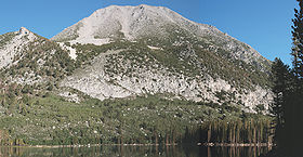
Mount Morgan from Davis LakeElevation 12,992+ feet (3,960+ m) [1] Prominence 1,472 ft (449 m) [1] Parent peak Red Slate Mountain [2] Listing Sierra Peaks Section [3] Location Location Mono County, California, USA Range Sierra Nevada Coordinates 37°30′41″N 118°46′47″W / 37.5113223°N 118.7798486°WCoordinates: 37°30′41″N 118°46′47″W / 37.5113223°N 118.7798486°W[4] Topo map USGS Convict Lake Climbing First ascent 1934 by David Brower and Norman Clyde [5] Easiest route Hike, class 1 [5] Mount Morgan is a mountain in the Sherwin Range of the Sierra Nevada. It lies in Mono County, California, between McGee Canyon and Hilton Lakes. It is not to be confused with the Mount Morgan that lies southwest of Little Lakes Valley, only 9 miles (14 km) to the south southwest. The mountain is in the John Muir Wilderness Area on the Inyo National Forest.
References
- ^ a b "Mount Morgan, California". Peakbagger.com. http://www.peakbagger.com/peak.aspx?pid=2650.
- ^ "Mount Gabb - California Mountain Atlas". Peaklist.org. http://www.PeakList.org/CAmtnatlas/tables/whitney/gabb.html. Retrieved 2009-01-18.
- ^ "Sierra Peaks Section List". Angeles Chapter, Sierra Club. http://angeles.sierraclub.org/sps/spslist.pdf.
- ^ "Mount Morgan". Geographic Names Information System, U.S. Geological Survey. http://geonames.usgs.gov/pls/gnispublic/f?p=gnispq:3:::NO::P3_FID:263831.
- ^ a b Roper, Steve (1976). The Climber's Guide to the High Sierra. San Francisco: Sierra Club Books. pp. 132, 340. ISBN 0-87156-147-6.
External links
- "Mount Morgan (N)". SummitPost.org. http://www.summitpost.org/page/152146.
Categories:- Mountains of Mono County, California
- Mountains of the John Muir Wilderness
- Sierra Nevada geography stubs
Wikimedia Foundation. 2010.
