- Commonwealth Bay
-
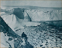
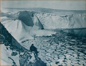
Commonwealth Bay is an open bay about 48 km (30 mi) wide at the entrance between Point Alden and Cape Gray in Antarctica. It was discovered in 1912 by the Australasian Antarctic Expedition under Douglas Mawson, who established the main base of the expedition at Cape Denison at the head of the bay. Named by Australasian Antarctic Expedition after the Commonwealth of Australia.
Katabatic winds
It is listed in both the Guinness Book of World Records and the Eighth Edition of the National Geographic Atlas as the windiest place on Earth with winds regularly exceeding 240 kilometres (150 mi) per hour and medium annual wind speed 80 kilometres (50 mi) per hour[1].
Storms are caused by katabatic wind - concentrated flow of cold air flowing along the steep surface of ice shield towards the sea and accelerated by increasing gradient of the surface of ice and cliff monolith at Cape Denison[1]. In summer there might be experienced periods of relative calm but during winter storms are especially strong and long lasting. It is characteristic that storms might start unexpectedly and last for long time, again ending unexpectedly. Abrupt start and end of storm might be accompanied by powerful whirlpools and expressive short-lived and fast moving cloud at the coast line[2].
In spite of the extreme weather, coast of Commonwealth Bay is important breeding area for Antarctic petrels, emperor penguins, and Adelie penguins.
References
- ^ a b Katabatic winds at Commonwealth Bay, Wondermondo, 27 September 2010, http://www.wondermondo.com/Countries/An/Antarctica/Antarctica/Commonwealth.htm
- ^ Ball, F.K. (1956), The Katabatic Winds of Adelie Land and King George V Land.
External links
- Life On Commonwealth Bay by Reuters journalist Pauline Askin
- Commonwealth Bay photographs on Flickr
Coordinates: 66°54′S 142°40′E / 66.9°S 142.667°E

This George V Land location article is a stub. You can help Wikipedia by expanding it.