- Culebrita
-
Culebrita Island Lighthouse 
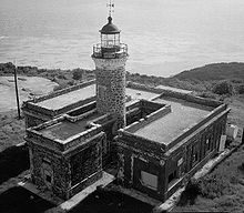
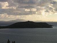
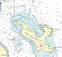
Image taken in 1978 Location Culebra, Puerto Rico Coordinates 18°18′49.3″N 65°13′38.8″W / 18.313694°N 65.227444°WCoordinates: 18°18′49.3″N 65°13′38.8″W / 18.313694°N 65.227444°W Year first lit 1886 Automated 1964 Foundation Stone Construction Stone Tower shape Cylindrical Markings / pattern Gray tower and red trim on dwelling Original lens Fourth order Fresnel.[1] ARLHS number PUR 004 Faro Isla de CulebritasGoverning body: U.S Coast Guard MPS: Lighthouse System of Puerto Rico TR NRHP Reference#: 81000686[2] Isla Culebrita (little Culebra, little snake) is a small island off the eastern coast of Culebra, Puerto Rico and is part of the Puerto Rico Archipielago. Together with Cayo Botella off the northwestern point, it belongs to the barrio Frailes of Culebra. It is a nature reserve and home of one of the oldest lighthouse in the Caribbean. The island is only accessible by private boat from the main island of Culebra.
Geography
Culebrita is a coral island approximately 1 mile in length. Tidal pools trap small sea life at low tide.
There are six beaches on Culebrita, the chief being Playa Tortuga (Turtle Beach). The beach is named for the many sea turtles that use the beach for breeding grounds and the surrounding waters for grazing. Sea turtles Tina and Ike call Playa Tortuga home. The other two large beachs are Trash Beach and West Beach. Trash Beach is on the windward side of the island and debris is often blown onto the beach. There are also large tidal pools on the east side of the island where people lounge as if they were large baths.
The Culebrita Reef lays off the southern coast of the island.
Lighthouse
Construction of the Culebrita Lighthouse began on September 25, 1882, and it was completed on February 25, 1886. The Spanish Crown built the lighthouse to help secure its claim over the main island of Culebra. It is the most eastern light outside mainland Puerto Rico. It guides navigation through the Virgin Passage and the Vieques Sound connecting in the Puerto Rico Light System with the Cape San Juan Light.
It was one of the oldest operating lighthouses in the Caribbean until 1975 when the U.S. Navy and Coast Guard finally closed the facility. The United States Coast Guard has replaced the lighthouse with a solar powered light beacon.
The Culebrita Lighthouse was registered on the U.S. National Register of Historic Places on October 22, 1981. However, no work has been done to maintain the facility. In 1989, Hurricane Hugo caused extensive damage, and the tower was destroyed by Hurricane Marilyn in 1995. The Culebra Foundation, starting in 1994, has tried to attract local and federal attention to save the lighthouse, but they have had little success. The lighthouse is in danger of collapsing.[3]
References
- ^ "Historic Light Station Information and Photography: Puerto Rico". United States Coast Guard Historian's Office. http://www.uscg.mil/history/weblighthouses/LHPR.asp. Retrieved 2009-03-30.
- ^ "Inventory of Historic Light Stations National Park Service". http://www.nps.gov/history/maritime/light/culeb.htm. Retrieved 2009-04-02.
- ^ "A punto de colapsar el Faro Culebrita" (in Spanish). Primera Hora. 2007. http://www.primerahora.com/noticia/isla_adentro/noticias/a_punto_de_colapsar_el_faro_culebrita/36965. Retrieved 2009-04-05.[dead link]
 Categories:
- Culebra, Puerto Rico
- Uninhabited islands of Puerto Rico
- Lighthouses in Puerto Rico
Wikimedia Foundation. 2010.


