- Thanlwin Bridge (Mawlamyaing)
Infobox Bridge
bridge_name=Thanlwin (Mawlamyaing) Bridge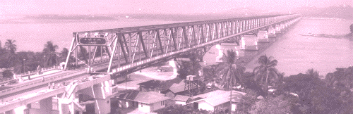
caption=
official_name= Thanlwin Bridge, (Mawlamyaing )
also_known_as=
carries= 2 lanes (SB and NB), 1 rail track (14 ft), 2 sidewalks(6 ft each)
crosses=Salween River viaShampoo Island
locale=Mawlamyaing andMottama ,Mon State
maint=Burma Ministry of Transportation
id=
design= Steel Frame Truss bridge, &Cantilever Bridge s and Access Bridges
mainspan=
length=Road bridge convert|1624|ft|m|abbr=on Mawlamyaing Bank, convert|2252|ft|m|abbr=on Mottama Bank, Main Frame ft to m|7699|abbr=yes|precision=0|wiki=yes or 2.2 miles (3.5 km) (total bridge)
Railbridge convert|6442|ft|m|abbr=on Mawlamyaing Bank, convert|7498|ft|m|abbr=on Mottama Bank, Main Frame convert|7699|ft|m|abbr=on, ft to m|21618|abbr=yes|precision=0|wiki=yes or 4.1 miles (total bridge)
width= 2 traffic lanes ~28 feet (~ 8.5 m), single rail track~14 ft(~4.3 m), 2 Sidewalks (~12 ft)
clearance=
below =
traffic= unknown
begin=18 March 2000
complete=18 April 2005
open=18 April 2005
closed=
toll= unknown
map_cue= Connects:
map_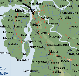
map_text= The Bridge linking 708 km highway.
map_width= 200px
lat= 96.5
long= 16.9Thanlwin Bridge (Mawlamyaing) is the longest bridge in
Burma cite news | url=http://www.mofa.gov.mm/news/feb5_sat05_2.html | title=Thanlwin Bridge (Mawlamyine), longest and largest in Myanmar, emerges to serve interests of State and region | date=2005-02-05] , and connects the city ofMawlamyaing withMottama . Constructed at the confluence of theThanlwin River, the Gyaing River and the Attayan River inMon State , the bridge has a two-mile-long motor road and four-mile-long railroad as well as pedestrian lanes.The approach structure of the rail bridge on Mawlamyaing bank is convert|1.22|mi|m long, and on Mottama bank is convert|1.42|mi|m miles long. The total length of the rail bridge is convert|4.75|mi|m 4.75 miles long. [cite news | url=http://mission.itu.ch/MISSIONS/Myanmar/06nlm/n060419.htm | title=Thanlwin Bridge (Mawlamyine) rail bridge opens | date=2006-04-19 | publisher=The New Light of Myanmar] The bridge was designed and built by Ministry of Construction.
References
Wikimedia Foundation. 2010.