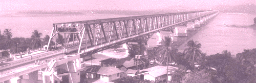
- Thanlwin Bridge (Mawlamyine)
-
Thanlwin (Mawlamyaing) Bridge 
သံလွင်တံတား (မော်လမြိုင်)Official name Thanlwin Bridge, (Mawlamyaing) Carries 2 lanes (SB and NB), 1 rail track (14 ft), 2 sidewalks(6 ft each) Crosses Salween River via Shampoo Island Locale Mawlamyaing and Mottama, Mon State Maintained by Ministry of Transportation Design Steel Frame Truss bridge, & Cantilever Bridges and Access Bridges Total length Road bridge 1,624 ft (495 m) Mawlamyaing Bank, 2,252 ft (686 m) Mottama Bank, Main Frame 7,699 ft (2,347 m) or 2.2 miles (3.5 km) (total bridge)
Rail bridge 6,442 ft (1,964 m) Mawlamyaing Bank, 7,498 ft (2,285 m) Mottama Bank, Main Frame 7,699 ft (2,347 m), 21,618 ft (6,589 m) or 4.1 miles (total bridge)Width 2 traffic lanes ~28 feet (~ 8.5 m), single rail track~14 ft(~4.3 m), 2 Sidewalks (~12 ft) Construction begin 18 March 2000 Construction end 18 April 2005 Opened 18 April 2005 Toll unknown Daily traffic unknown Connects:
The Bridge linking 708 km highway.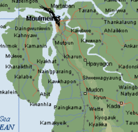
Coordinates 16°30′40″N 97°37′04″E / 16.51111°N 97.61778°ECoordinates: 16°30′40″N 97°37′04″E / 16.51111°N 97.61778°E Thanlwin Bridge (Mawlamyaing) is the longest bridge in Burma[1], and connects the city of Mawlamyaing with Mottama. Constructed at the confluence of the Thanlwin River, the Gyaing River and the Attayan River in Mon State, the bridge has a two-mile (3 km)-long motor road and four-mile (6 km)-long railroad as well as pedestrian lanes.[1]
The approach structure of the rail bridge on Mawlamyaing bank is 1.22 miles (1,960 m) long, and on Mottama bank is 1.42 miles (2,290 m) long. The total length of the rail bridge is 4.75 miles (7,640 m) long.[2] The bridge was designed and built by Ministry of Construction.[1]
References
- ^ a b c "Thanlwin Bridge (Mawlamyine), longest and largest in Myanmar, emerges to serve interests of State and region". 2005-02-05. http://www.mofa.gov.mm/news/feb5_sat05_2.html.
- ^ "Thanlwin Bridge (Mawlamyine) rail bridge opens". The New Light of Myanmar. 2006-04-19. http://mission.itu.ch/MISSIONS/Myanmar/06nlm/n060419.htm.
Categories:- Bridges in Burma
- Mon State
- Bridges completed in 2005

Wikimedia Foundation. 2010.