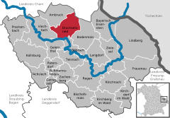
- Drachselsried
-
Drachselsried 
Coordinates 49°6′N 13°1′E / 49.1°N 13.01667°ECoordinates: 49°6′N 13°1′E / 49.1°N 13.01667°E Administration Country Germany State Bavaria Admin. region Lower Bavaria District Regen Mayor Johann Weininger (CSU) Basic statistics Area 41.73 km2 (16.11 sq mi) Elevation 435 - 1,284 m Population 2,371 (31 December 2010)[1] - Density 57 /km2 (147 /sq mi) Other information Time zone CET/CEST (UTC+1/+2) Licence plate REG Postal code 94256 Area code 09945 Website www.drachselsried.de Drachselsried is a municipality in the district of Regen, in Bavaria, Germany. Drachselsried is in the Zeller Valley (German: Zellertal), and is part of the Glass Road (Glasstrasse) The area is part of the Bavarian Forest National Park. The village is a small, highly organised, friendly place to live. Bayern Eins, the German radio station, gave some history details of the village, which was first noted in 1184. More Info.[1]
Achslach | Arnbruck | Bayerisch Eisenstein | Bischofsmais | Böbrach | Bodenmais | Drachselsried | Frauenau | Geiersthal | Gotteszell | Kirchberg im Wald | Kirchdorf im Wald | Kollnburg | Langdorf | Lindberg | Patersdorf | Prackenbach | Regen | Rinchnach | Ruhmannsfelden | Teisnach | Viechtach | Zachenberg | ZwieselReferences
- ^ "Fortschreibung des Bevölkerungsstandes" (in German). Bayerisches Landesamt für Statistik und Datenverarbeitung. 31 December 2010. https://www.statistikdaten.bayern.de/genesis/online?language=de&sequenz=tabelleErgebnis&selectionname=12411-009r&sachmerkmal=QUASTI&sachschluessel=SQUART04&startjahr=2010&endjahr=2010.
Categories:- Geography articles needing translation from German Wikipedia
- Municipalities in Bavaria
- Regen district
- Bavarian Forest
- Lower Bavaria geography stubs
Wikimedia Foundation. 2010.


